
Marcus’ 4 a.m. Wednesday forecast
INDIANAPOLIS (WISH) — We’re tracking a double threat this week—heavy rainfall with flash flooding concerns Friday, followed by a prolonged heat wave that could push heat indices into the low 100s next week.
Today:
High pressure is giving us a nice, quiet day with plenty of sunshine and comfortable conditions. Highs will reach the low 80s with lower humidity.


Tonight: Storms Return
Scattered showers and thunderstorms will develop tonight as a frontal boundary approaches the region. This marks the beginning of an active weather pattern that’ll stick with us through the first half of the weekend.

Lows will drop into the 50s.
Thursday: Scattered Storms
Thursday brings continued scattered storm chances, especially across southern Indiana. It won’t be a washout, but expect periods of rain and storms throughout the day.

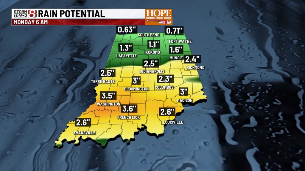
Friday: Flash Flooding Threat
From late Thursday night through Friday, we’re tracking the potential for heavy rainfall—1 to 3 inches is possible across much of Central and Southern Indiana.

We’ve had a lot of rain recently, and the ground is already saturated. When you add high precipitable water values (a lot of moisture in the atmosphere) to already wet ground, you get a recipe for flash flooding.
Here’s what to expect:
- Heavy rain, especially Friday morning through afternoon
- Flash flooding possible in low-lying areas, poor drainage spots, and urban areas
- Creeks and streams could rise quickly
- Road flooding likely in flood-prone areas


This Weekend: Storms Continue Before Pattern Shift
The frontal boundary will linger over the area Friday and Saturday, keeping scattered storm chances in the forecast. Some areas could pick up additional rainfall on top of what falls Friday. The frontal system will gradually move out of the state late Saturday night.
Sunday Through Next Week: Heat Wave Arrives
A ridge of high pressure will build over the region Sunday, and that’s when the heat and humidity really crank up.

Here’s what we’re tracking:
- Multiple days with temperatures in the 90s
- Heat indices climbing into the low 100s during the afternoon hours
- High humidity making it feel even hotter
- Limited relief overnight—lows only dropping into the 70s
This will be the hottest weather we’ve seen in a while, and many days will be bordering on heat advisory criteria.
Looking Ahead to July 4th Weekend
The heat may begin to ease slightly as we approach the July Fourth holiday weekend, but we’ll still be dealing with above-normal temperatures. Storm chances will also return as the pattern becomes more unsettled.
7-Day Outlook

About The Author
You may also like
-
Storms with heavy rain to close out the week, hot & humid next week
-
Man faces charges, accused of stalking and harassing Indiana Fever guard Sophie Cunningham
-
Missing 13-year-old swimmer found dead near Michigan City lighthouse after multi-agency search
-
Gunfire shakes SE Indianapolis neighborhood for third time in a month
-
16-year-old is 2nd juvenile arrested after man fatally shot behind Marion strip club