
4 PM WEATHER 6-24-26
INDIANAPOLIS (WISH) — Unsettled weather is coming back to close out the work week.
WEDNESDAY NIGHT:
Partly to mostly cloudy. Chance of a few showers & storms. Lows in the low to mid 60s.

THURSDAY:
Variably cloudy. Chance of a few showers & storms. A few gusty storms are possible but the threat of severe weather remains low. Locally heavy rain and lightning could occur with any storm that develops. Highs should be mainly in the lower 80s.


THURSDAY NIGHT – FRIDAY:
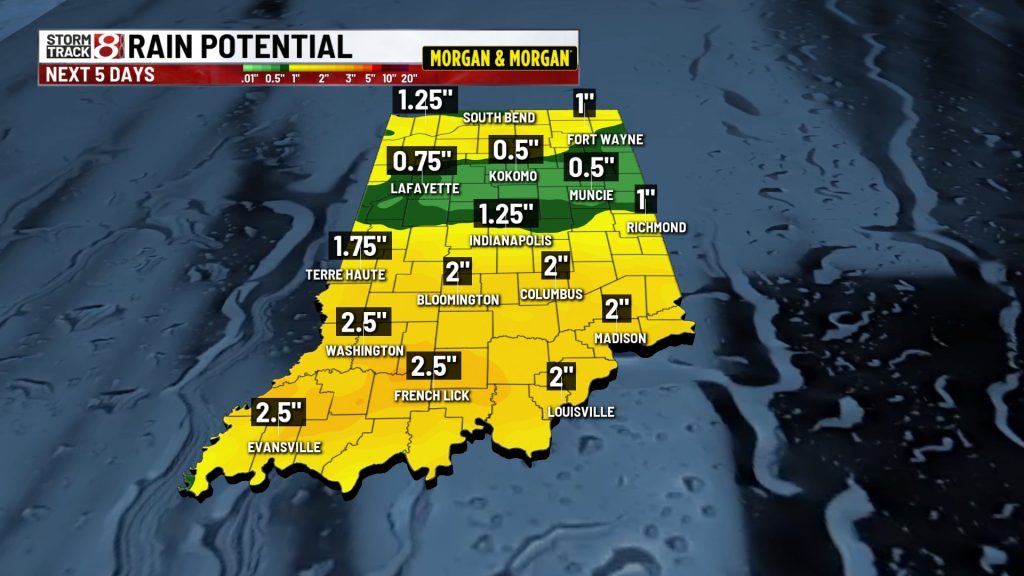
Scattered rain & storms are looking more likely. Some heavy rain is possible and the latest projections suggest another 1-3” could fall across parts of Central and Southern Indiana. We’ll continue to monitor for some severe weather potential because that threat is not zero either. Temperatures look like they’ll stay in the 70s on Friday.
WEEKEND:
Low 80s are likely Saturday with mid 80s on Sunday. Humidity levels will be rising and the heat index by Sunday afternoon could be well into the 90s. We are going to keep the chance of a few showers and storms going both days but the weekend shouldn’t be a washout. It’ll become much more humid.
NEXT WEEK:
A hot and humid weather pattern is likely going to establish itself again over the Great Lakes region. While there could be a few stray storms from time to time and perhaps even a storm complex or two that rolls in, the main storyline will involve hot & muggy air. Highs are expected to push into the lower 90s with heat indices in the 100 to 105 range, if not higher in some locations.

About The Author
You may also like
-
Indianapolis braces for heavy rain and heat wave
-
Man faces charges, accused of stalking and harassing Indiana Fever guard Sophie Cunningham
-
Missing 13-year-old swimmer found dead near Michigan City lighthouse after multi-agency search
-
Gunfire shakes SE Indianapolis neighborhood for third time in a month
-
16-year-old is 2nd juvenile arrested after man fatally shot behind Marion strip club