
Marcus’ 4 a.m. Thursday forecast
INDIANAPOLIS (WISH) — Central Indiana is still dealing with flooding concerns this Thursday morning as heavy rain continues to move south of the region today.
Flooding Remains the Main Concern
The threat of severe storms wrapped up before 4 a.m., but flooding is expected to persist through the morning hours. Flood watches are transitioning to flood advisories and warnings in local areas as rivers, creeks, and low-lying spots remain saturated.
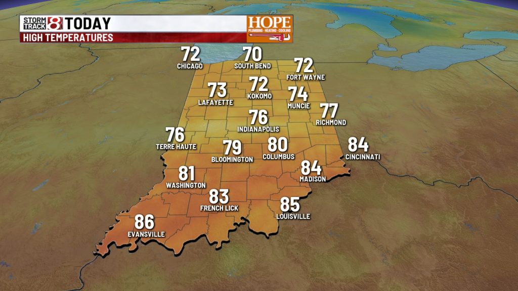
Today:
High temperatures will stay below normal, ranging from the lower 70s in northern Indiana to around 80 degrees in the south. Cloud cover will dominate, and a few sprinkles or light showers are possible this afternoon.


Tonight and Friday:
Quiet weather returns tonight as high pressure builds over the state. Lows will drop into the 50s—great sleeping weather. Friday looks much better with mainly sunny skies and highs in the 70s. It’ll be a nice break from all the wet weather.


Weekend Outlook:
A weak system could bring a few scattered showers on Saturday. Highs will stay in the middle 70s to around 80 degrees—still comfortable, though humidity may start creeping back up.

More significant rain chances return Sunday and Monday. An upper-level wave and low-pressure system are expected to move through, potentially bringing nearly an inch of rain across the area. The best chance for rain looks to be Sunday night into Monday morning.
Extended Forecast:
The trend of below-normal temperatures is expected to continue through Wednesday. High pressure will try to keep things dry during the middle of next week, but additional energy in the atmosphere may trigger a few showers around Wednesday.
About The Author
You may also like
-
2 tornadoes confirmed in Jackson, Monroe counties from Wednesday storms
-
Tornado watch, issued for 47 counties, includes Indianapolis area
-
Major severe storm risk continues through 3 a.m.; all modes of severe weather remain possible
-
Severe storms threaten central Indiana Wednesday; tornadoes and destructive winds possible | June 17, 2026
-
IMPD responds to downtown stabbing at Indiana Convention Center