
 Interactive radar | Download the WISH-TV weather app for localized alerts
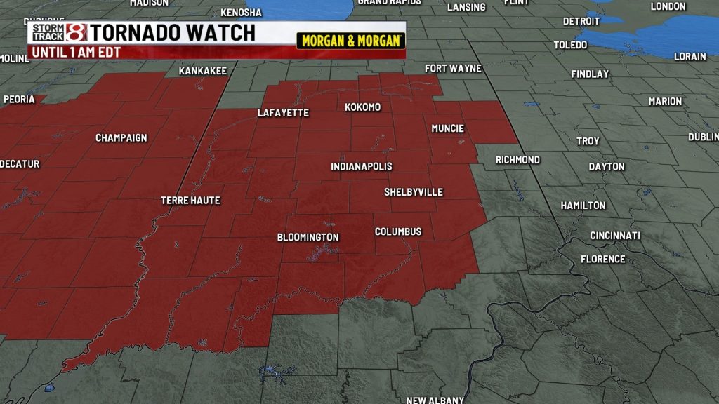
(WISH) — A tornado watch has been issued through 1 a.m. EDT Thursday for much of Indiana, the National Weather Service’s Storm Prediction Center said.
The watch area covers 47 of Indiana’s 92 counties, and includes Indianapolis and its surrounding counties.
Counties in the watch area are Bartholomew, Blackford, Boone, Brown, Carroll, Cass, Clay, Clinton, Daviess, Decatur, Delaware, Fountain, Grant, Greene, Hamilton, Hancock, Hendricks, Henry, Howard, Huntington, Jackson, Jay, Jennings, Johnson, Knox, Lawrence, Madison, Marion, Martin, Miami, Monroe, Montgomery, Morgan, Owen, Parke, Putnam, Randolph, Rush, Shelby, Sullivan, Tippecanoe, Tipton, Vermillion, Vigo, Wabash, Warren, and White.
WRTV Meteorologist Ryan Morse says Wednesday afternoon’s rain was the first of two rounds coming to the Hoosier state. A line of supercells were expected to form in Illinois and travel into central Indiana.
In neighboring Illinois, dozens of counties are under a tornado watch until 10 p.m. CDT/11 p.m. EST.
All threats of severe weather were on the table: damaging wind, strong tornadoes, large hail, and flooding.
Severe storms should exit Indiana in the early morning hours.
WISH-TV Meteorologist Keith Gibson says people should have multiple ways of getting alerts and have electronic devices fully charged in case they lose power.
The next chance for rain after these storms could be on Saturday.
About The Author

You may also like
-
Indianapolis crews rescue drivers, shelters open, volunteers assist amid flooding
-
Noblesville Mayor declares state of emergency amid historic flooding, evacuations underway
-
White River predicted to crest at 20 feet as Mayor Hogsett declares emergency
-
Indianapolis officials urge evacuation near White River
-
Two IMPD officers shot on Indianapolis’ west side; suspect in custody