
Interactive radar | For personalized alerts, download the WISH-TV weather app
NORMAN, Okla. (WISH) — Two tornado watches are in effect for Thursday night in Indiana, the National Weather Service’s Storm Prediction Center says.
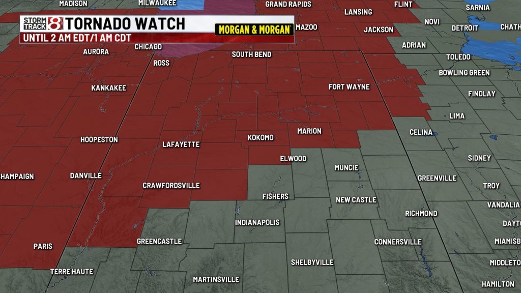
The watches do not include Indianapolis or Marion County, although Boone County, northwest of Indianapolis, is part of the watch area.
The center at 8:05 p.m. Thursday issued a tornado watch until 2 a.m. Friday for parts of central Indiana, much of northern Indiana, and 10 Illinois counties. Indiana cities in this watch area include Crawfordsville, Elkhart, Fort Wayne, Kokomo, Lafayette, Logansport, Marion and South Bend. Indiana counties in this watch area are Adams, Allen, Blackford, Boone, Carroll, Cass, Clinton, DeKalb, Elkhart, Fountain, Fulton, Grant, Howard, La Porte, Marshall, Miami, Montgomery, Noble, Parke, Pulaski, St. Joseph, Tipton, Vermillion, Wabash, Warren, Wells, White and Whitley.
The center at 1:55 p.m. Thursday issued a tornado watch until 10 p.m. EDT/9 p.m. CDT for these Indiana counties: Benton, Jasper, Lake, Newton and Porter. Dozens of Illinois counties are also part of this watch.
The latest forecast from News 8 said a big line of strong-to-severe storms will move across central Indiana sometime between 10 p.m. Thursday and 2 a.m. Friday. Primary threats will be damaging wind gusts, possible spin-up tornadoes, and hail. Heavy rain may lead to flooding again in some areas.
Temperatures by sunrise Friday, in the wake of the rain, should be mainly in the 60s.
About The Author
You may also like
-
Line of strong storms tonight, nice summer weather the next 2 days
-
IMPD warns against sudden gatherings
-
Honda recalls 800,000 vehicles for rear suspension defect
-
Heat wave continues, more storms expected tonight | June 11, 2026
-
Indiana households struggle as essential costs outpace inflation for 15th year