
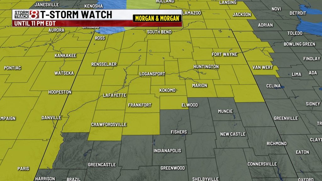
NORMAN, Okla. (WISH) — Two thunderstorm watches are in effect Wednesday night the northern half of Indiana, the National Weather Service Storm Prediction Center said.
Indianapolis and Marion County are not a part of the watch areas, although neighboring Boone County is. The Lafayette and Kokomo areas are part of the watch areas.
The first watch was issued at 3:40 p.m. ET for five counties in northeast Indiana: Benton, Jasper, Lake, Newton and Porter. That watch goes through 11 p.m. EDT/10 p.m. CDT.
The second watch was issued at 5:40 p.m. ET for Adams, Allen, Blackford, Boone, Carroll, Cass, Clinton, DeKalb, Elkhart, Howard, Fulton, Grant, Howard, Huntington, Jay, Kosciusko, LaGrange, La Porte, Marshall, Miami, Montgomery, Noble, Pulaski, St. Joseph, Starke, Steuben, Tippecanoe, Tipton, Vermillion, Wabash, Warren, Wells, White and Whitley.
In his latest forecast, Storm Track 8 Chief Meteorologist said a few isolated storms are possible, with the best chance in the northern half of the state. Storms could produce some strong winds, and heavy rain will also be a threat.
About The Author
You may also like
-
Honda recalls 800,000 vehicles for rear suspension defect
-
Heat wave continues, more storms expected tonight | June 11, 2026
-
Indiana households struggle as essential costs outpace inflation for 15th year
-
Boy dies after being hit by vehicle in Westfield
-
Person dies in motorcycle, SUV crash at Harding Street intersection