
4 PM WEATHER 7-20-26
INDIANAPOLIS (WISH) — A WEATHER ALERT continues as we monitor the threat of gusty storms later tonight into Tuesday morning along with lingering wildfire smoke. A few days of fall-like weather remain on track later in the week.

MONDAY EVENING/NIGHT:
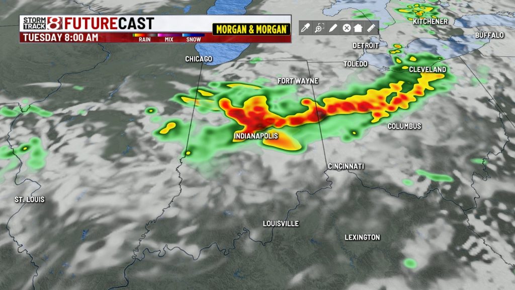
Warm and humid conditions continue this evening under fair skies. After midnight and into the wee hours of the overnight hours, a batch of strong/severe storms may approach from the northwest. The storms will likely move into our area in a weakened state, but they could still produce some gusty winds, lightning, and heavy downpours. The locally dense wildfire smoke we’ve been dealing with since Sunday should continue to improve. Lows will be in the lower 70s.

TUESDAY:
Morning rain & storms, some of which could be strong/gusty, will eventually fizzle out and associated cloud cover should thin out by early afternoon.

A cold front will move through during the afternoon, and until it passes, there is still a chance of storm redevelopment, some of which could end up strong or severe. It’s uncertain if they will flare back up across Central Indiana or do so just to our southeast. Odds are higher for far SE Indiana, Ohio, and Kentucky Tuesday afternoon.

Highs should top out in the mid 80s. Humidity levels look to remain high for most of the day, but they will sharply drop during the evening hours.

Additional smoky haze may be pushed back into Indiana as the cold front passes through during the day. Some of our hi-res guidance suggests this may be the case.

TUESDAY NIGHT:
Fair skies with much lower humidity. Lows in the 60s.
WEDNESDAY & THURSDAY:
Mostly sunny to partly cloudy skies, low humidity, and fall-like temperatures mainly in the mid to upper 70s. Overnight lows in the 50s are likely. This will be a really nice stretch of weather so try to take advantage if you can. We’ll still have to watch out for more elevated smoky haze.
FRIDAY-SUNDAY:
Partly cloudy skies continue, but temperatures are going to warm back into the 80s. Some upper 80s are possible by Sunday. There could be a few showers & storms returning to the region by the end of the weekend or early next week. Conditions still look good at IMS for the Pennzoil 250 Saturday and Brickyard 400 Sunday. The Indy Eleven match Saturday evening also looks very nice!

About The Author

You may also like
-
From the barn to the show ring: How the Dickerson family prepares their cattle
-
Trump imposes 50% tariffs on most Canadian goods over alleged discrimination
-
‘There’s a hole in my heart’: Coach of boxer Hannah Rapp mourns her sudden death
-
Smokey to storms today, some strong storms possible Tuesday | July 20, 2026
-
US service member killed in Iraq drone detonation; 17 dead in ongoing war