
4 PM WEATHER 6-8-26
INDIANAPOLIS (WISH) — Warm, humid, and stormy weather will continue for most of the week before things settle down a bit for the coming weekend.

MONDAY EVENING/NIGHT:
Scattered rain & storms may produce locally heavy rain and flooding. Muggy lows around 70 are expected.


TUESDAY:
More scattered rain & storms are likely. Locally heavy rain remains possible and some storms could end up being gusty at some point. Highs should climb back into the mid 80s. Dew point values in the lower 70s will keep things sultry.


TUESDAY NIGHT:
Additional rain & scattered storms are possible. Muggy lows in the lower 70s continue.
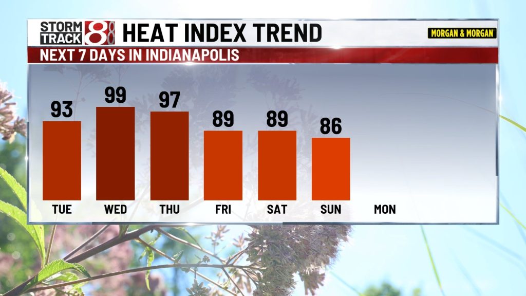
WEDNESDAY:
While some storms may pop up, the day as a whole doesn’t appear as it will be as wet as other days this week. Highs will be near 90 with heat indices around 100.
THURSDAY & THURSDAY NIGHT:
Highs near 90 with heat indices around 100 are on the table once again. Some scattered storms could develop during the heating of the day but there is a greater chance of more widespread activity during the evening and overnight hours into early Friday morning. A batch of strong to severe storms with damaging wind gusts could develop along a cold front.


FRIDAY THROUGH THE WEEKEND:
A noticeable drop in humidity should occur during the day Friday and it won’t be AS humid during the coming weekend. Temperatures drop a bit too, mainly into the mid to low 80s with overnight lows falling back into the 60s. The chance for a little more rain & thunder returns Sunday into early next week.

About The Author
You may also like
-
Workers begin removing Trump’s name from the Kennedy Center, hours after a court-ordered deadline
-
Toddler, mom living at Indiana Women’s Prison prepare for life on the outside
-
Deputy sent to hospital after being shot in Owen County
-
IMPD arrests suspect, victim in near north side shooting on attempted murder, gun charges
-
Pedestrian dies after being hit by a train near Rockville Road