
Marcus’ 4 a.m. Wednesday forecast
INDIANAPOLIS (WISH) — Central Indiana is settling into a very pleasant late-July pattern that will carry us through Friday before rain chances return for the weekend.
Pleasant Through Friday:
High pressure building in from the northwest is keeping our weather quiet and stable through the end of the work week. This is textbook summertime high pressure—not the bitterly cold, Canadian kind we get in winter, but the gentle, pleasant kind that brings sunshine and comfortable conditions.
Comfortable Humidity
The key to the pleasant conditions over the next few days is the humidity—or rather, the lack of oppressive humidity. Dew points will hover in the low 60s during the day, making for very comfortable afternoons. At night, those dew points will dip into the upper 50s, which will make for crisp, refreshing evenings.
This is what meteorologists call the “Goldilocks zone” of humidity. It’s not bone-dry (which can be uncomfortable in its own way), and it’s certainly not oppressive. It’s just right.
The Hazy Sky:
While the forecast is mostly clear through Friday, you might notice something a bit unusual about the sky. Instead of that deep, rich blue we typically see on clear summer days, the sky may have a “milky” or hazy appearance. The sun might look a bit washed out, and the horizon could appear cloudier than it actually is.
This is courtesy of wildfire smoke drifting in from upstream—in this case, from wildfires burning in western Canada and the northwestern United States. Winds high in the atmosphere, typically 15,000 to 30,000 feet above the ground, are pulling this smoke into our region.
The good news is that the smoke is staying at high altitudes, well above where we breathe. Air quality at the surface is expected to remain in the “good” to “moderate” range, which means most people won’t experience any health effects.

Seasonal Temperatures: Right Where We Should Be
High temperatures will stay right where they should be for this time of year, topping out between 84 and 87 degrees. These are very typical late-July temperatures for central Indiana.
To put that in perspective, the normal high temperature for Indianapolis at the end of July is 85°F. So we’re essentially running right at seasonal averages—not particularly hot, not particularly cool. Just typical summer weather.
Overnight lows in the low to mid-60s are also right on target for this time of year. These comfortable nights are perfect for outdoor activities or just enjoying time on the patio.
Weekend Rain Chance:
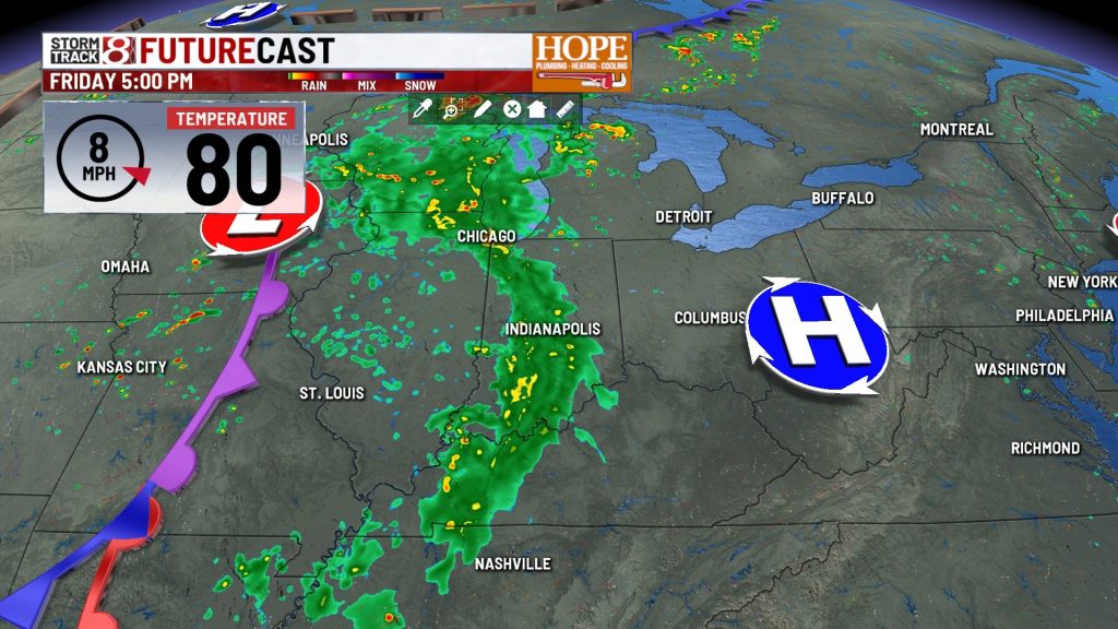
The quiet weather pattern begins to break down as we head into the weekend.
A sluggish area of low pressure is expected to develop over the Plains on Friday and slowly drift toward Indiana over the weekend. This system is bringing rain and thunderstorm chances back into the forecast for Saturday and Sunday, with the potential for some heavy downpours in spots.
The Cutoff Low Problem
In most weather systems, a low-pressure area moves along with the main jet stream—the ribbon of fast-moving air high in the atmosphere that essentially steers weather systems from west to east across the country. These systems are relatively predictable because they move at a fairly consistent pace and follow a fairly consistent path.
A cutoff low is different. It’s a low-pressure system that literally “cuts off” or detaches from the main jet stream. When that happens, the steering winds that normally move weather systems along disappear, and the low-pressure area becomes sluggish and meandering.
Think of it like a leaf floating down a stream. As long as it stays in the main current, you can predict where it’s going to go. But if it gets caught in an eddy or a still spot, it just kind of sits there and slowly drifts, and it becomes much harder to predict its path.
Why This Matters for the Forecast
Because cutoff lows move very slowly and erratically, they’re notoriously difficult for computer forecast models to handle with precision. The models can capture the overall pattern—yes, there will be a low-pressure system, and yes, it will bring rain—but the exact timing, track, and intensity can vary significantly from one model run to the next.
Where the models disagree is on the exact timing and track. Some solutions have the system moving through more quickly (better weather by Sunday afternoon), while others keep it around longer (rain continuing through Sunday night).
Current Weekend Outlook
Here’s what we’re thinking right now, with the understanding that this will likely be refined over the next 24-48 hours:
Saturday:
Timing Note: The exact timing of when rain begins Saturday and when it ends Sunday is still uncertain. We’ll have a much better handle on this by Thursday afternoon and Friday morning as new model data comes in.
Not a Washout, But Have a Plan
It’s important to emphasize that this doesn’t look like a total washout weekend. This isn’t a situation where it’s going to rain continuously for 48 hours straight. Instead, we’re looking at periods of rain and thunderstorms with some drier gaps mixed in.
If you have outdoor plans this weekend:
Heavy Rain Potential
One concern with slow-moving weather systems like this is the potential for heavy rainfall. When storms are moving along at a good clip, they drop their rain and move on. But when they’re moving slowly or training (multiple storms moving over the same area), rainfall totals can add up quickly.
Forecast rainfall totals for Saturday and Sunday combined range from about 0.75 inches to 2.25 inches, with locally higher amounts possible if storms train over the same locations.

August Warm-Up: Heat Returns Next Week
Once this weekend’s weather system moves out, the weather pattern is going to make a significant shift as we head into the first week of August.
The main jet stream—the fast-moving river of air high in the atmosphere that acts as a dividing line between hot and cold air masses—is expected to retreat well to our north. When that happens, it opens the door for warmer air to surge back into the state from the south and southwest.
What This Means
As we look ahead to the first week of August, expect a warming trend to take hold by the middle of next week. Temperatures will climb back into the upper 80s to low 90s, and humidity levels will increase as well.
7-Day Forecast Summary

About The Author

You may also like
-
ISP: Lynn town marshal killed while deploying stop sticks during police chase
-
Greenwood man missing since June found dead in Owen County, police say
-
Widow of fallen deputy settles lawsuit against trucking companies, drivers
-
Man arrested for 2023 double homicide on Indy’s near north side
-
Charges filed against Columbus man accused of murdering landlord during his eviction