
Marcus’ 4 a.m. Tuesday forecast
INDIANAPOLIS (WISH) — Central Indiana is in for an active stretch of weather as a potent storm system heads our way. While scattered storms are possible today, all eyes are on Wednesday when severe weather looks likely across the region. Here’s your detailed breakdown.
Today (Tuesday):
The morning starts quiet with partly cloudy skies. Southwest winds will increase through the day as two rounds of scattered showers and thunderstorms push through.
First round: Expect a scattered line of storms to move east across the area during the afternoon hours.
Second round: A second line follows late this afternoon and early evening near a cold front.

Most of today’s activity will stay below severe levels, though an isolated strong storm can’t be ruled out—especially in northern Indiana. The main threats with any stronger storms would be gusty winds and heavy downpours.

Highs will reach the mid-70s to around 80 degrees.

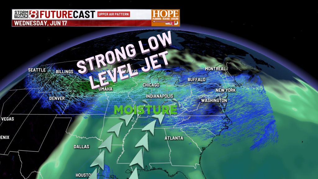
Wednesday: Two Rounds of Severe Weather
Wednesday will be a Storm Track 8 weather alert day.

What to Expect:
Round 1 – Late Morning and Afternoon: A thunderstorm complex will move across the northern half of Central Indiana. Heavy rain and some severe cells are possible, particularly near a warm front in northern sections of the state. Any storms that turn severe would mainly have a damaging wind threat.

Round 2 – Evening and Overnight: This is the main event. A second, more intense round of storms is expected ahead of a cold front, and all modes of severe weather are on the table.

- Tornadoes: The threat will be highest in northern Indiana near the warm front, but tornadoes are possible anywhere across Central Indiana. A few strong tornadoes are possible.
- Damaging winds: This will be highest concern with the evening line. Significant wind gusts over 80mph could be possible along the strongest segments of the line of storms.
- Large hail: Also possible, especially with any supercells that develop.

Another outlying issue – gradient winds will be strong. Wind gusts could reach over 40 mph on Wednesday.
Record-Breaking System:
This storm is so strong that if the surface low-pressure center deepens as expected, it could set record-low pressure values for the month of June in lower Michigan. That tells you just how unusual and powerful this system is.
Safety First:
Make sure you have multiple ways to receive weather warnings on Wednesday. Enable your phone’s emergency alerts, have a weather radio ready, and keep WISH-TV Storm Track 8 on standby. Know where your safe space is at home and at work.
When severe weather warnings are issued, take them seriously and get to safety immediately.
7-Day Forecast:
- Thursday: The cold front may linger in southern Indiana, keeping a chance of rain in the forecast. Temperatures will be cooler.
- Friday through the Weekend: Below-normal temperatures persist with mostly dry conditions.
- Sunday Night: Our next chance for rain arrives.
- Early Next Week: Temperatures return to near-normal levels.

Wednesday’s severe weather threat is real, and preparation is key. Stay weather-aware, have a plan, and check back for updates as we fine-tune the timing and threats.
Stay safe.
— Marcus Bailey, WISH-TV Storm Track 8
About The Author
You may also like
-
Family sues Carmel Catholic school for inaction on son’s harassment, assault
-
Strong to severe storms possible Tuesday, bigger severe event Wednesday
-
Lawsuit accuses Greenwood pool contractor of ‘deceptive’ practices following I-Team investigation
-
IMPD seeks 84-year-old man with dementia missing from south side
-
Cooler Start to Your Week; Severe Storms Possible Wednesday | June 15, 2026