
Marcus’ 4 a.m. Thursday forecast
INDIANAPOLIS (WISH) — Severa rain chances could lead to flooding issues for parts of the state through the start of the weekend.
Today
Scattered storms will redevelop across southern and southwestern Indiana this afternoon, concentrated especially along and south of the I-70 corridor. These storms will be capable of producing heavy rainfall and localized flooding, particularly in the southern third of the state. Rainfall amounts between 1 and 3 inches are possible, with southwest Indiana facing the greatest flood threat.


Tonight
Storms will diminish overnight but isolated showers and storms will linger through the early morning hours, mainly across southern Indiana. Overnight lows will hold in the mid to upper 60s.

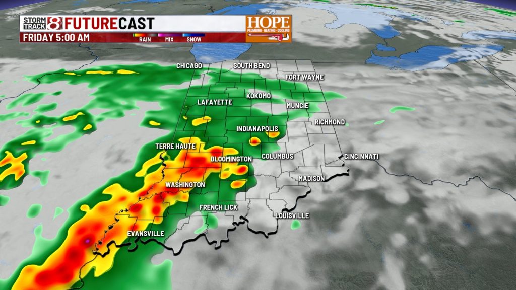
Friday — Heavy Rain Threat
A Flood Watch is in effect for southwestern Indiana as a slow-moving frontal boundary stalls over the southern part of the state. Expect widespread storm clusters that will drop the bulk of the heavy rain Friday afternoon through evening. Localized totals could reach 1 to 3 inches, with the highest amounts again focused in the southwest. Flood-prone areas and small streams are at risk for rising water and potential flash flooding.


Saturday
The frontal boundary lingers, keeping the threat of scattered thunderstorms alive, mainly across southern and central Indiana. Storm intensity may be slightly diminished but localized heavy downpours remain possible. Highs will reach the upper 70s to low 80s across the state.
Sunday — Transition Day
A building ridge of high pressure will push storms out as the state shifts toward drier, sunnier conditions. Expect partly to mostly sunny skies with highs climbing into the mid/upper-80s.

Next Week: Heat Wave Arrives
From Monday onward, prepare for the most dangerous heat of the summer so far. High pressure will dominate, pushing temperatures into the mid to upper 90s by midweek, with heat index values topping out in the low 100s across much of central and southern Indiana. Overnight lows will stay in the mid-70s to low 80s, offering little nighttime relief.
7 day forecast:

About The Author
You may also like
-
Caitlin Clark leaves game vs Mercury with back injury
-
Former Purdue star Braden Smith selected by Pacers in NBA Draft
-
Storms with heavy rain to close out the week, hot & humid next week
-
Indianapolis braces for heavy rain and heat wave
-
Man faces charges, accused of stalking and harassing Indiana Fever guard Sophie Cunningham