
Marcus’ 4 a.m. Friday forecast
INDIANAPOLIS (WISH) — A shift in the weather pattern with increasing humidity and scattered showers in Central Indiana. Potential for severe wind gusts and isolated large hail, especially along the I-74 corridor.
Today: Enjoy It — Last Pleasant Day for a While
One more nice day before the pattern flips. Skies will be partly sunny with temperatures reaching the mid-80s, but the main story today is the wind — gusts of 20 to 30 mph during the afternoon. Dew points will climb through the day, and you’ll notice the air feeling thicker by evening.

A few showers may pop in northern portions of the state through early evening, but most of Central Indiana stays dry through the afternoon.

Tonight: Storms Possible North and West
The first round of organized showers and storms arrives tonight, focused north of I-70. A couple of marginally strong or severe wind gusts can’t be ruled out late tonight, though the threat is limited. Most areas see showers at most.
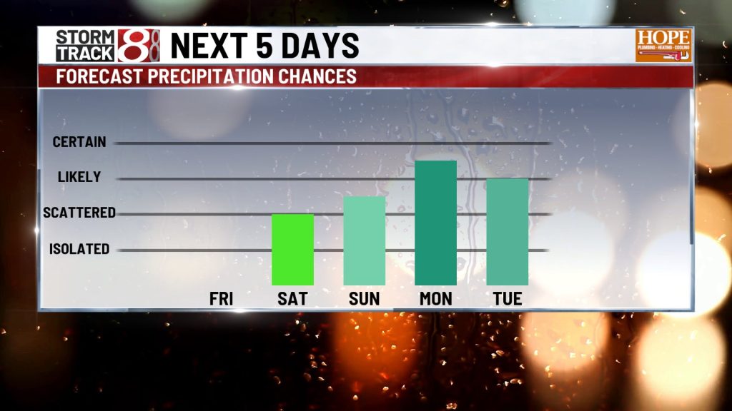
Saturday: More Widespread Rain, Storms Likely Saturday Night
Additional rounds of showers and storms push through Saturday. The best chances for organized and potentially stronger convection arrives Saturday night. Marginally severe wind gusts and isolated large hail are possible with the stronger cells. Areas south of I-70 will likely see lower rain coverage.
Sunday Through Wednesday: Hot, Humid, and Persistently Unsettled
This is the main headline of the forecast — a significant pattern change arriving for the start of next week and likely lasting through at least Wednesday.
A big pull of Gulf moisture will be surging into the state starting this weekend and by next week, the humidity will be oppressive. Dew points climb into the upper 60s by Sunday morning and push into the low 70s by Tuesday .
Scattered to at times numerous showers and embedded thunderstorms are expected through at least Wednesday, with rounds possible on any given afternoon or evening.
With multiple rounds of heavy rain expected over several days, isolated flash flooding becomes an increasing concern heading into next week, particularly for areas that receive repeated hits from training storms.
Late Next Week: First 90° Day Possible
Should the upper ridge build over the central U.S. and allow ample sunshine back into Indiana late next week, temperatures could reach the low 90s — which would be Indianapolis’s highest reading of 2026 so far. With the high humidity, we’ll likely see heat indices near 100°.

About The Author
You may also like
-
‘Welcome to Indiana!’: Braun cheers Bears’ decision to move ahead with stadium project
-
Charges filed after 12-year-old Indianapolis boy shot by 9-year-old brother
-
Warm and dry conditions continue before humid and stormy weather moves in | June 4, 2026
-
IMPD arrests boy after fatal shooting of 23-year-old in downtown parking garage
-
What happened to Lauren Spierer? Missing IU student case still haunts Bloomington 15 years later