
Marcus’ 4 a.m. Thursday forecast
INDIANAPOLIS (WISH) — Central Indiana’s heat wave will reach its peak today, with afternoon heat index values soaring as high as 110 degrees.
An Excessive Heat Warning remains in effect through Friday evening.
Today Through Friday: Peak Heat
A strong upper-level ridge remains stationed over the Midwest, trapping a layer of hot and humid air across the region. This blocking pattern will persist through Friday night.
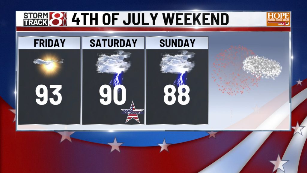
High temperatures will climb into the low to mid-90s Thursday and Friday afternoons.

Dew points will remain in the mid to upper 70s throughout the period—exceptionally high moisture content for the region. Combined with the heat, this will push heat index values between 105 and 110 degrees during peak afternoon heating hours, roughly from noon through 6 p.m.


Storm chances will remain near zero through most of each day. The ridge is simply too strong to allow for convective development. However, a few isolated storms may develop late Friday afternoon along the outside edge of the heat dome as it begins to weaken. Widespread rainfall is not expected.
Overnight lows will provide little relief, only dropping into the mid-70s to low 80s across most of central Indiana.
Fourth of July Holiday Weekend: Pattern Change Begins
As we move into the holiday weekend, a notable shift will occur. The high pressure system will gradually weaken and shift southward, allowing central Indiana to open up to daily chances for scattered showers and thunderstorms from Saturday through Monday.
While the storms won’t be part of an organized severe weather system, some individual cells could produce heavy rainfall and gusty winds. Residents planning outdoor Fourth of July activities should monitor the forecast closely and have backup plans ready.
High temperatures will remain warm, in the upper 80s to low 90s, but storm coverage and cloud cover will help prevent heat indices from reaching the extreme levels seen earlier in the week.
Tuesday-Wednesday: Cold Front Brings Relief
More significant relief is on the way by midweek. A cold front will push through Indiana Tuesday into Wednesday, bringing a much cooler and drier air mass behind it.
This front will effectively break the heat dome that has dominated the region for days. By Wednesday and into the latter half of next week, temperatures are forecast to return to near or slightly below normal seasonal levels—a dramatic turnaround from the dangerous heat currently gripping the state.
High temperatures by midweek should fall into the upper 70s to low 80s, with much lower humidity levels making it feel considerably more comfortable.
7-Day Forecast Summary

About The Author
You may also like
-
Cellphone ban and child protection laws take effect in Indiana
-
Data center zoning proposal heads to Indianapolis council
-
Indiana auto systems maker to shut down Terre Haute plant, cut 207 jobs
-
Advocates warn Trump administration moves could roll back disability rights
-
‘I’m in danger’: Court docs detail how an unruly passenger forced an emergency landing at IND airport