
Marcus’ 4 a.m. Monday forecast
INDIANAPOLIS (WISH) — Central Indiana faces hazy sunshine and warm temperatures Monday before a storm complex brings risks of damaging winds and localized flooding starting late tonight.
Haze Lingers Today
High pressure will dominate Monday, keeping conditions dry with highs climbing into the 80s. Smoke from Canadian wildfires continues drifting over the region, filtering sunshine and creating a milky appearance to the sky throughout the afternoon.

While the haze may not be as pronounced as Sunday, those with respiratory sensitivities should limit prolonged outdoor exposure during peak afternoon hours.

Storms Target the Overnight Hours
The weather pattern shifts dramatically tonight. A cold front advancing from the Great Lakes is expected to trigger a large complex of thunderstorms northwest of central Indiana.
Confidence is growing that these storms will move into the region late tonight, persisting into early Tuesday morning. The primary threats include damaging wind gusts and torrential rainfall.

With tropical moisture levels near 2 inches—exceptionally high for our area—these storms will be capable of producing intense rainfall in a short period. Localized flooding is a significant concern during the predawn hours Tuesday, particularly in low-lying areas and locations with poor drainage.
Tuesday Storm Chances
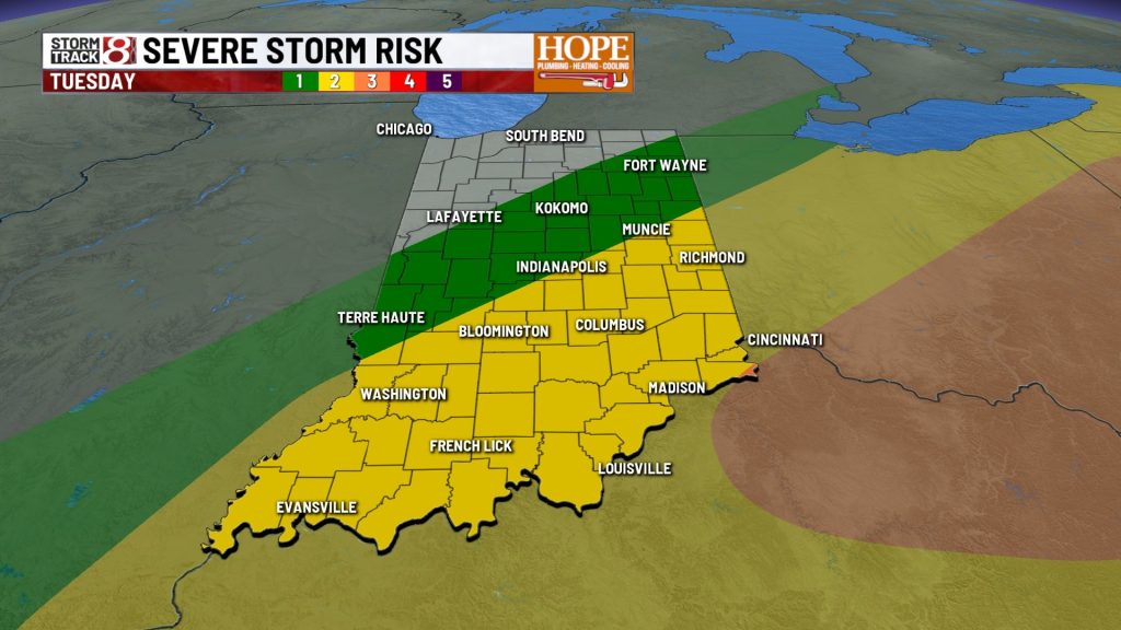
Tuesday’s forecast depends heavily on how the overnight storms unfold. If cloud cover lingers through the morning, it could suppress the energy needed for new storms to develop during the afternoon.

However, if skies clear and sunshine returns, additional storms could fire up along the cold front Tuesday afternoon. Current models suggest the highest severe weather risk Tuesday will be southeast of the Indy metro.

Noticeable Cooldown Ahead
Once the cold front exits the state Tuesday evening, a much cooler and drier air mass will settle in behind it.
We’re looking at a beautiful stretch of weather for the second half of the workweek. High temperatures will range from the mid-70s to low 80s through Friday—a noticeable drop from recent days.
Perhaps the most welcome change will come at night. Low temperatures will drop into the 50s for a couple of nights, offering a rare opportunity to open the windows and give the air conditioner a break in late July.
This cooldown will be brief. Temperatures are expected to rebound closer to seasonal norms by the weekend, with highs back in the mid- to upper 80s.
7 Day Forecast:

About The Author

You may also like
-
From the barn to the show ring: How the Dickerson family prepares their cattle
-
Trump imposes 50% tariffs on most Canadian goods over alleged discrimination
-
Strong storms possible late tonight & Tuesday AM, early taste of September to end the week
-
‘There’s a hole in my heart’: Coach of boxer Hannah Rapp mourns her sudden death
-
US service member killed in Iraq drone detonation; 17 dead in ongoing war