
Marcus’ 5 a.m. Monday forecast
INDIANAPOLIS (WISH) — Cooler temperatures continue through the early part of this week, but all eyes are turning to Wednesday as a significant severe weather threat develops across Central Indiana. Here’s your detailed outlook.
Today:
You’ll notice cooler temperatures sticking around with highs in the low to mid-70s. Expect mostly dry skies today with a mix of sun and clouds. It’s a comfortable change from recent weather, and it’s a good time to enjoy the milder conditions before storm chances return.


Tonight:
Temperatures fall into the 50s with mainly clear skies. High pressure keeps things stable for now, making for a cool and refreshing evening.

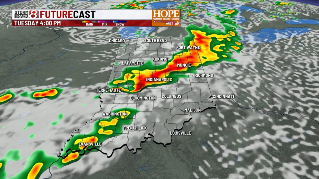
Tuesday:
A weather system moving down from Wisconsin will spark scattered showers and thunderstorms in the afternoon.
Most storms will be multicell clusters, though a few isolated supercells could form, especially in northwest Indiana and northern Illinois. The main risks are strong wind gusts and large hail. The threat should decrease as the system moves eastward in the evening.
Keep an eye on the sky if you’re in northwest areas—but overall, Tuesday’s severe threat remains on the marginal side.

Wednesday: Severe Weather Threat Rises
Wednesday is shaping up as the most active day this week. A strong low-pressure system over the upper Midwest will pull warm, moist air into Indiana, creating a volatile environment prone to severe storms.
Two Scenarios to Watch:
Scenario 1 – Morning to Afternoon Storms: Storms may develop early over Iowa and push southeast into Indiana. This could bring damaging winds and localized flooding if the system arrives this way.
Scenario 2 – Evening Frontal Development: If the atmosphere stays clear during the day, heat and humidity will build, fueling powerful storms along a cold front moving through Illinois. This scenario could produce all types of severe weather, including supercells and tornadoes, before the storms merge into a damaging wind line.

7-Day Forecast:
- Cooler-than-average temperatures continue with highs mainly in the 70s through the weekend.
- Showers and storms possible throughout the week, with the best chance for severe weather on Wednesday.
- No heat waves expected; enjoy the mild but unsettled weather pattern.
- Persistent cloud cover and below-normal temperatures expected to continue through Sunday.

About The Author
You may also like
-
US and Iran reach agreement to end war, reopen Strait of Hormuz
-
Indianapolis police seek help finding missing woman with dementia
-
6-year-old hospitalized after being pulled from Kokomo retention pond
-
Shooting in downtown Indianapolis leaves two injured, police investigating
-
Rain & storm chance through early Sunday PM, bigger storm threat midweek