
Marcus’ 4 a.m. Wednesday forecast
INDIANAPOLIS (WISH) — Warm and muggy conditions continue to fuel our active weather pattern, with several rounds of showers and thunderstorms expected through tonight. Some of these storms could be strong to severe.
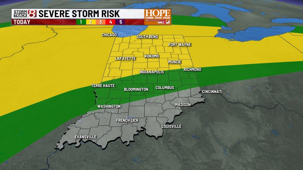
Storms are expected this afternoon and evening.
After quiet conditions to start the day, our attention returns to thunderstorm development later in the afternoon and evening hours, mainly across central and northern Indiana.
Storms will likely begin to fire sometime after lunchtime, with the greatest coverage during the late afternoon and evening hours—mainly along and north of Interstate 70. That is where we have a Level 2 out of 5 risk for severe storms.

All modes of severe weather are possible, with the main threats being damaging winds and large hail. An isolated tornado cannot be ruled out.

In addition to any severe storms, frequent lightning and heavy downpours will be likely with any storms that develop this afternoon and evening.
Warm and muggy conditions continue
Temperatures will once again climb into the low to mid 80s today, challenging the record high of 84° set back in 2002. With some of the higher dew points, it will feel even a bit warmer.

More storm chances through the week
A cold front approaches the region on Thursday, bringing a good chance for widespread showers and a few gusty thunderstorms. Most of the state is in a Level 1 out of 5 risk for severe storms Thursday, with damaging winds and large hail as the primary threats.


Friday will be the driest day of the work week, with partly cloudy skies and near-record highs pushing into the mid 80s.
On Saturday, a sharp cold front will swing through the state, bringing widespread showers and storms. Most of the state is highlighted with a risk for severe weather on Saturday, with all modes of severe weather possible.

Cooler air arrives this weekend
Following Saturday’s cold front, temperatures will take a very quick plunge. Overnight lows will fall into the upper 30s and lower 40s Saturday night, and high temperatures will struggle to make it out of the mid 50s for many areas on Sunday.

Frost potential early next week
Sunday night into Monday morning will be the coldest, with overnight lows likely slipping into the mid 30s. Depending on sky cover and winds, there will likely be a risk of frost across much of central Indiana.

Seven-day forecast
The pattern looks to quiet down a bit as we head into early next week. High temperatures will rebound to the low 60s on Monday and climb back into the lower 70s for Tuesday through the middle of next week.

About The Author
You may also like
-
WB I-465 closed in Carmel due to cut gas line
-
Protesters rally against new board’s impact on Indianapolis education funding
-
Severe thunderstorm watch issued for Indianapolis area, northern Indiana
-
‘It was horrible’: Woman shares story of alleged abuse at Lebanon faith-based program for teens
-
Trey Williams sentenced to 6 years in death of former HSE football star Mason Alexander