
Watch live | Interactive radar | Storm Track 8 weather app | Watches & warnings | Hourly forecast | Wind gusts
INDIANAPOLIS (WISH) — A batch of strong/severe storms will move across southern Indiana Sunday evening. Damaging wind gusts to 60 mph appear to be the main concern at this time. Torrential rainfall and dangerous lightning are also occurring.


8:54 p.m.
Weather Alert: Severe Thunderstorm Warning for Greene, Lawrence, and Monroe County until 9:30pm.
Severe Thunderstorm Warning including Owensburg IN, Williams IN and Crane IN until 9:30 PM EDT

8:21 p.m.
Weather Alert: Severe Thunderstorm Warning for Greene County until 8:45pm.
Severe Thunderstorm Warning including Linton IN, Bloomfield IN and Lyons IN until 8:45 PM EDT. This storm will contain wind gusts to 70 MPH!

8:10 p.m.
Weather Alert: Severe Thunderstorm Warning for Greene County until 9:00pm.
Severe Thunderstorm Warning including Bicknell IN, Freelandville IN and Elnora IN until 9:00 PM EDT

7:46 p.m.
Weather Alert: Severe Thunderstorm Warning for Clay and Greene County until 8:30pm.
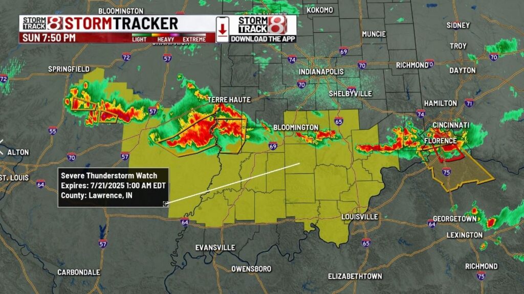
7:09 p.m.
Weather Alert: Severe Thunderstorm Watch for portions of the area until 1:00am.
7 p.m.
Weather Alert: Severe Thunderstorm Warning for Clay and Greene County until 7:45pm.
6:20 p.m.
Weather Alert: Severe Thunderstorm Warning for Clay County until 7:00pm.
9:55 a.m.
Weather Alert: Severe Thunderstorm Warning for Tippecanoe County until 10:30am.
About The Author
You may also like
-
5 men arrested for child solicitation in Grant County
-
Clark expected to miss Tuesday’s game in New York
-
Caitlin Clark’s message on social media after ‘incredible’ All-Star Weekend
-
Storm threat lingers to start the week, then intense heat builds midweek | July 20, 2025
-
IMPD chief: No curfew violations during WNBA All-Star/Indiana Black Expo weekend