
July 7, 2025 morning forecast with Tara Hastings
INDIANAPOLIS (WISH) – Mild and muggy to start out the work week. We will look for a few spotty showers or thunderstorms into the afternoon with more rain chances possible later in the week.
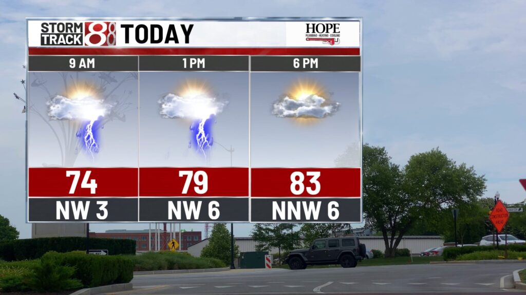
TODAY: Partly to mostly cloudy skies throughout the day today. It will be warm and incredibly humid as well. We have a cold front that is going to move across the state and that will bring us some showers and thunderstorms for the afternoon hours. These thunderstorms will likely be slow movers which means we could pick up some intense rainfall across parts of Central Indiana.


It is going to be very humid with dew point values climbing to the upper 60s and lower 70s. Temperatures today will stay into the ’80s of the little bit more cloud cover. Even though we will not see temperatures into the lower 90s like we did over the weekend it is still going to feel rather uncomfortable.
TONIGHT: Rain comes to an end later tonight. We will hang on to a few clouds early on. The sky begins to clear overnight and low temperatures will fall into the upper 60s.

TOMORROW: Dry conditions heading into your Tuesday with lots of sunshine. There may be a few spotty showers or storms later in the evening across parts of southern Indiana. Humidity values are still a bit on the higher side with temperatures climbing into the upper ’80s.


7 DAY EXTENDED FORECAST: Storm chances increase throughout the rest of the week. We will be in an active pattern where we will look for some spotty showers and thunderstorms into the afternoon hours through the rest of the work week.

Partly cloudy on Wednesday with highs into the mid-80s. It stays on the muggy side for the rest of the week as well. Showers and thunderstorms possible Thursday and Friday afternoon as well.


About The Author
You may also like
-
Warm and humid with some rain chances across central Indiana this week | July 8, 2025
-
Woman killed after hit by SUV while walking on Kentucky Avenue
-
ISP investigating Greenfield Police shooting
-
Indianapolis allocates $4 million for improved snow removal efforts
-
Indiana Silver Alert issued for 89-year-old missing in Posey County