
Marcus’ 4 a.m. Tuesday forecast
INDIANAPOLIS (WISH) — Spotty storm chances will continue through Wednesday evening.
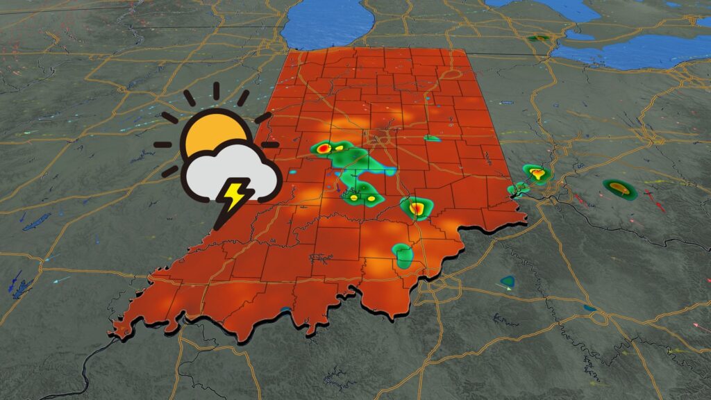
Today:
Showers and thunderstorms will persist this morning as a weakening convective system moves through Central Indiana. Expect occasional showers and storms through the early morning hours, significantly diminishing by mid to late morning.

Due to very slow storm motion, like last night, we could experience localized heavy downpours and minor flooding issues.
Warm and humid conditions are expected through the afternoon, with highs returning to the mid-80s.

A few pop-up showers and thunderstorms may occur during the peak heating of the afternoon through early evening.
Wednesday:
Wednesday will feature a similar setup, with mostly sunny to partly cloudy skies for much of the day. Pop-up showers and thunderstorms are possible in the mid to late afternoon.
High temperatures will reach the mid-80s, which is near average for this time of year.
Late week:
Thursday and Friday will be hot and humid but likely dry. High temperatures will approach 90°F to wrap up the work and school week.

7 day forecast:
Warm and muggy conditions will persist into the weekend. Saturday is expected to be dry with highs in the upper 80s. A cold front approaching on Sunday may bring showers and thunderstorms.
The front will stall early next week, bringing more widespread showers and thunderstorms to the area to start the workweek on Monday.

The long-range pattern suggests temperatures will remain near or slightly above average through mid-August.
About The Author
You may also like
-
Wicked World of Croquet returns to Benjamin Harrison Presidential Site
-
3 men arrested for shooting at ‘large party of young people’ in Clarksville
-
Gen Con 2025 breaks attendance record
-
Explore Indianapolis’ vibrant food scene at Devour Indy Summerfest
-
IMPD promotes safety and unity during National Night Out