
Wed evening forecast – Apr 30, 2025
INDIANAPOLIS (WISH) — We are monitoring a risk for strong to severe storms into Wednesday night and again on Thursday to open May. We’ll also track more in the way of showers and storms going towards this weekend.
A ***Tornado Watch*** remains in effect until 11 PM EDT for areas just southwest of Indianapolis.

Wednesday night: Scattered showers and storms are expected into the nighttime hours as a warm front gradually shifts northward. There could be some discrete cells that eventually merge into a cluster.


This warm front will also lead way to a threat for strong to severe storms. There is a Slight Risk (2/5) for areas southwest of Indy. A Marginal Risk (1/5) is up to a Crawfordsville-New Castle line. The main threat is wind, but isolated tornadoes and hail are also possible.

Lows in the low 60s.

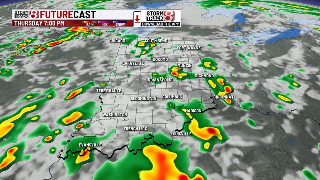
Thursday: The theme to start May will be on and off showers and storms throughout the day.


Isolated to scattered strong to severe storms are possible Thursday afternoon and evening. There is a Slight Risk (2/5) across southern Indiana and most of central Indiana. Wind is the main concern, but large hail and an isolated tornado are also possible.

Highs in the mid 70s. It will also be a breezy day with wind gusts up to 25-35 MPH at times.

Friday: Additional scattered showers and isolated rumbles of thunder are possible Friday. Highs look to top out in the low 70s.

7-Day Forecast: We could have a few showers linger into Saturday, but we’re expecting a mostly dry day. For those racing in the Indy Mini-Marathon, the chance for a few showers is in place with temperatures ranging from the upper 40s to low 50s. We’ll warm back up into the mid 70s by next Tuesday.

About The Author
You may also like
-
Police: Therapist at autism center admitted to molesting infant, paying for child porn on Snapchat
-
Trump injects new dose of uncertainty in tariffs as he pushes start date back to Aug. 7
-
Inflation, tariffs drive up back-to-school costs for parents
-
Fired bus aide charged with battery after video shows he hit autistic student
-
Magistrate convicts 39-year-old man in violent domestic battery case