
Marcus’ 4 a.m. Friday forecast
INDIANAPOLIS (WISH) — Heat indices could exceed 100°F over the next couple of days.
Today:
High pressure will begin to build across the eastern portions of the country, leading to a jump in temperatures and humidity starting today. Expect high temperatures to reach the low 90s. With higher dewpoint numbers, feels-like temperatures will peak in the mid-90s this afternoon, just shy of heat advisory criteria.
Tonight:
Patchy fog may develop overnight but should not be widespread. Conditions will be muggier overnight, with lows falling to around 70°.
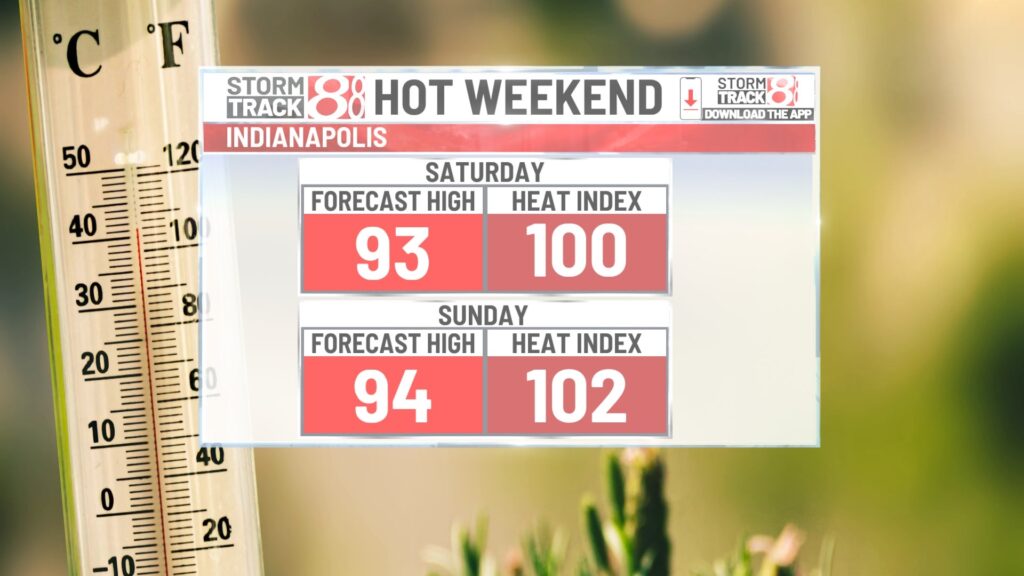
Weekend:
Temperatures could reach the hottest of the season this weekend. On both Saturday and Sunday, highs will climb into the mid-90s, with feels-like temperatures ranging between 101°F and 105°F for Saturday, Sunday, and Monday.
Rain chances will be very limited this weekend. There is a slight chance of showers and thunderstorms on Sunday as a weakening system moves in from the north and west. The highest probability for precipitation on Sunday will be in the northern portions of the state.
Similar precipitation chances apply to Monday. No widespread convection is expected, but some isolated showers and thunderstorms could occur Monday afternoon and evening.
7 day forecast:
High temperatures will persist through at least the middle of the week, with slightly better rain chances on Tuesday and Wednesday. Highs will remain in the low to mid-90s on Tuesday but should cool down starting Wednesday as a cooler weather pattern develops for the second half of the week.

Temperatures are expected to remain seasonal through Thursday, with likely dry conditions. Even cooler temperatures are possible heading into Friday and the following weekend.
About The Author
You may also like
-
Sweltering weekend with increasing rain/storm chances | Aug. 15, 2025
-
Homeless man living with cancer at Fountain Square camp finds housing, hospice
-
Man arrested for running over woman with car multiple times in Elkhart
-
DC sues to block Trump’s federal takeover of its police department as intervention intensifies
-
IMPD increasing patrols after attempted rape on Monon Trail