
Marcus’ 4 a.m. Tuesday forecast
INDIANAPOLIS (WISH) — Several days of dangerous heat move in starting Wednesday.
Today:
Beautiful weather is expected on Tuesday as high pressure continues to strengthen across the eastern United States. Expect mostly sunny skies, near-average temperatures, and, most importantly, lower dewpoint temperatures. Highs will reach the mid- to upper 80s, but dewpoint temperatures in the mid-60s will make for a relatively comfortable late July afternoon.
Tonight:
Humidity will begin to rise later this evening into the overnight hours. Otherwise, conditions will remain quiet with mostly clear skies and lows in the mid- to upper 60s.
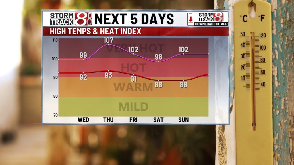
Hot and humid stretch:
Hot and humid conditions will return as a ridge builds overhead starting Wednesday. Expect several days with high temperatures in the low to mid-90s through the end of the workweek. Dewpoint temperatures will climb into the low to mid-70s, pushing heat indices between 100 and 105 for Wednesday, Thursday, and Friday. Heat advisories are already in place for the western portion of the state on Wednesday, and they may expand into central Indiana for the rest of the week.
Dry conditions are expected through at least early Thursday, as this area of high pressure and hot dome of air keeps us dry. Some isolated showers and thunderstorms may develop by Thursday afternoon and evening, but they will likely be few and far between.
Slightly higher chances for rain will arrive on Friday as the ridge begins to break down. Even so, most areas will likely remain dry to wrap up the workweek.
Weekend storms?
A more active weather pattern is expected as we head into the weekend. Showers and thunderstorms will become more likely with a northwesterly flow starting on Saturday. Similar to last weekend, several waves of storms may move through the state. It’s too early to pinpoint the exact timing of these waves, but numerous chances for showers and storms are possible to kick off the weekend.
At this point, severe weather appears unlikely, but heavy rain, frequent lightning, and some gusty winds are possible with any storms that develop on Saturday.
As of now, Sunday has a lower chance of showers and thunderstorms. Any storms that do occur could produce heavy rainfall.
7 day forecast:
High temperatures over the weekend will reach the upper 80s. Hot conditions will persist into the new workweek, with highs in the low 90s for Monday and Tuesday. There are indications that temperatures may finally cool to more seasonable levels by the middle of next week as we wrap up the month of July.

About The Author
You may also like
-
Cookie Monster to serve as grand marshal for Brickyard 400
-
Indianapolis golf event raises funds for ALS research in 14th year
-
The Cabaret in Indianapolis mourns death of Malcolm-Jamal Warner
-
Indianapolis police department swears in 33rd recruit class
-
IPS social worker aims to expand program creating safe spaces for teens