
Marcus’ 5 a.m. Sunday forecast
INDIANAPOLIS (WISH) — Scattered storms and torrential downpours expected this afternoon and evening across central Indiana.
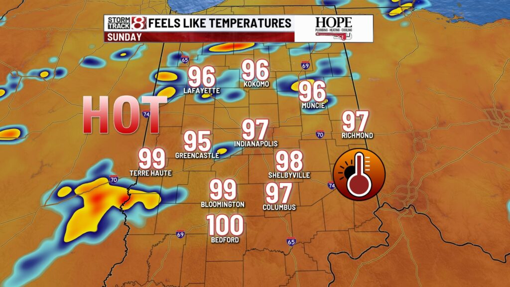
Today:
A clear, quiet, and muggy start to our Sunday morning with mostly clear skies. Expect mostly sunny conditions through much of the morning, with a few clouds developing by midday.
A cold front will approach in the afternoon, bringing scattered showers and thunderstorms for the second half of the day. No severe weather is expected, but heavy downpours are possible at times.

High temperatures will reach the low 90s before the rain arrives. The heat index will climb into the mid to upper 90s, potentially nearing 100°F in the southern portions of the state.

Tonight:
Showers and thunderstorms will diminish tonight with the loss of daytime heating. Expect partly to mostly cloudy skies overnight, with lows dropping to the lower 70s.
This week:
A typical July pattern will set up for the workweek, featuring warm temperatures, muggy conditions, and near-daily chances of pop-up showers and thunderstorms in the afternoon and early evening. No severe weather is expected, but heavy downpours are possible with any storms that develop.
High temperatures will reach the mid-80s on Monday.
Midweek temperatures will hover in the mid to upper 80s.
On Wednesday, a weak upper-level wave and surface front will increase the chance of scattered showers and thunderstorms.
7 day forecast:
Steamy conditions will persist through the end of the week. Another frontal boundary could bring scattered showers and thunderstorms to the region over the weekend. Temperatures are expected to remain above average for the next 7 to 10 days.

About The Author
You may also like
-
59-year-old woman dead after 2-vehicle crash in Howard County
-
Azura Stevens’ double-double lifts Sparks over Fever
-
What needs to change so Indianapolis can handle more curfew detentions
-
Trump’s freeze on education grants threatens Indiana programs
-
Kokomo man found dead after crashing vehicle into residence