
INDIANAPOLIS (WISH) — Hurricane Erin has been battling wind shear on Tuesday.
The storm as of 2 p.m. ET Tuesday had weakened to a Category 2 hurricane with maximum sustained winds of 105 mph advisory, according to the National Hurricane Center.


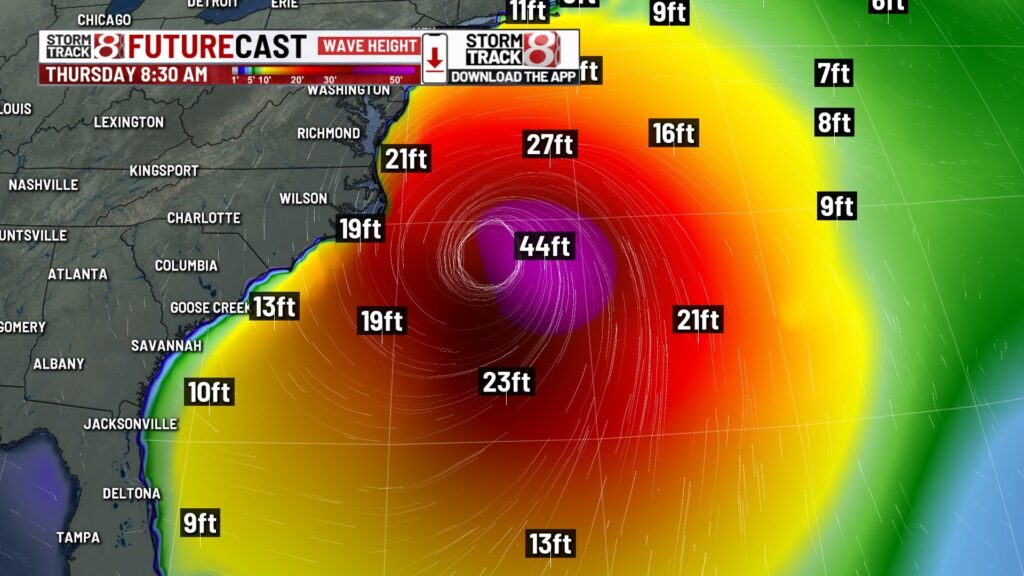
Erin’s main impact on the U.S. will be dangerous surf or rip currents. This system’s core will remain offshore, but outer rain bands and tropical storm-force winds are possible for the Outer Banks of North Carolina.

Tropical storm warnings are in place for North Carolina, with tropical storm watches for eastern Virginia.
Wave heights will peak for North Carolina late Wednesday into Thursday. Storm surge warnings are also out for these locations.


By Friday, 15-20 foot waves are possible off the New England coast.
Be sure to visit our weather stories page for further updates on Hurricane Erin.
About The Author
You may also like
-
IND airport dog Chica competes in TSA’s Cutest Canine Contest
-
‘UnPHILtered’ | Festival chair talks about helping students back in school
-
Person dies after being found shot in northwest Indianapolis parking lot
-
Next step ahead for proposed Google data center in Franklin Township
-
Sophie Cunningham ‘in good spirits’ despite season-ending knee injury