
July 23 | Evening Forecast with Chief Meteorologist Keith Gibson
INDIANAPOLIS (WISH) — Wednesday began our several day stretch of sweltering heat and humidity. We look to see the worst of the heat index Thursday with rain/storm chances ramping up into Friday.
Wednesday night: Warm and very humid tonight under mostly clear skies with lows in the mid 70s.


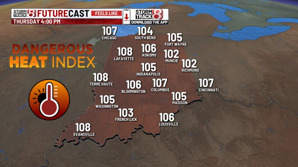
Thursday: The worst of the heat arrives tomorrow after an already warm start to the day. Highs will push into the low to mid 90s. Dew point values in the mid to upper 70s will cause heat indices to soar as high as into the 105-110 range.


Now, we could have spotty showers and storms develop across central and southern Indiana with increased cloud cover. Areas along and north of a Muncie-Lafayette line could have a complex of showers and storms late Thursday into early Friday with an isolated stronger storm risk.

Friday: The hot dome begins to break down through the end of the workweek, which will amp up our rain/storm chance. Scattered showers and storms are likely, especially north of interstate 70 as a front enters our state.


Highs will still be on the warmer side with numbers in the upper 80s to low 90s. Peak heat index values will be in the 100s for those who don’t deal with as much rain and cloud cover.

7-Day Forecast: The aforementioned front looks to slowly move back northward through Saturday. There will likely be multiple waves of showers and storms with this front, and areas north of interstate 70 currently have the better shot to see repeated rounds of activity. Muggy air will continue to swamp us through this weekend into early next week with dew point values up to the mid to upper 70s at times.


About The Author
You may also like
-
Woman gets 12 years in prison for downtown, Broad Ripple crime spree
-
Colts battle high temperatures at training camp
-
Video shows Noblesville gun store burglary on Fourth of July
-
Negotiations set to resume for 8,000 Kroger employees in Indiana
-
Family remembers woman shot and killed by husband before deadly Indy police chase