Latest

Heatwave to bring excessive heat and humidity to central Indiana later this week | July 21, 2025

Marcus’ 4 a.m. Monday forecast

INDIANAPOLIS (WISH) — A brief break from hot and muggy conditions is expected before another round of intense heat returns to central Indiana this week.

Today;

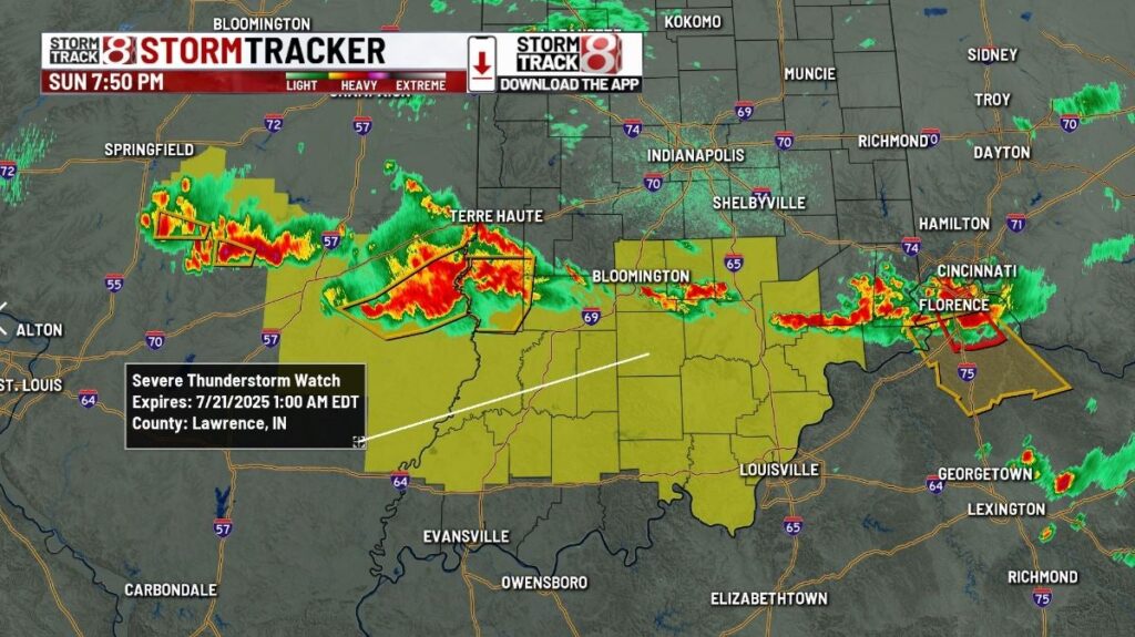
Showers are slowly moving out of the state this morning along a slow-moving boundary that has been draped across the region since the start of the weekend. Expect showers to continue pushing south and southwest throughout the morning, leaving most areas dry with mostly cloudy skies early and partly cloudy to mostly sunny skies by late afternoon.

High temperatures will reach the mid-80s, which is reasonable. Humidity will be elevated but not extremely high, making for a pleasant afternoon.

Tonight:

Very pleasant conditions are expected overnight with drier air in place and mostly clear skies. Overnight lows will fall to the mid-60s across the state.

Tuesday:

Tuesday should be another nice day with sunny skies from start to finish. Slightly warmer temperatures are expected, but humidity will remain in check. Highs will reach the mid- to upper 80s.

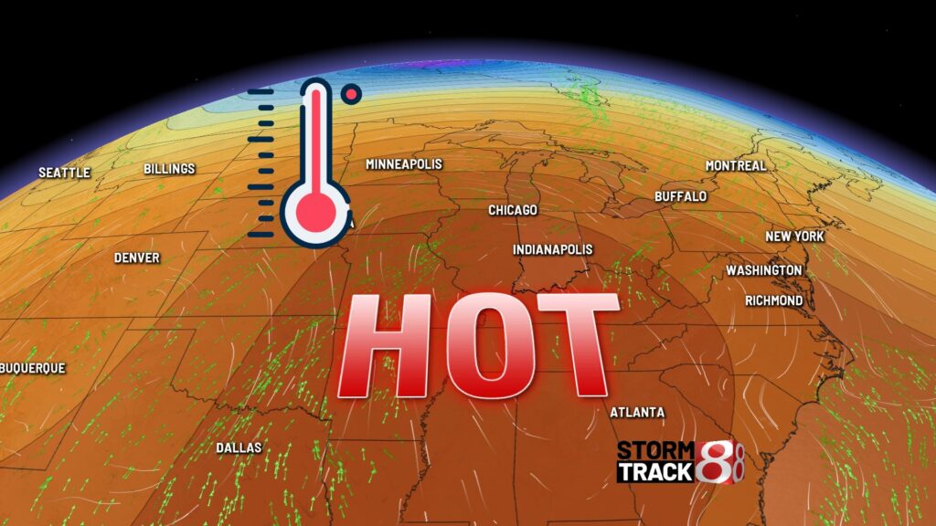
Extreme heat returns:

Humidity will begin to rise as early as late Tuesday night. Combined with a large heat dome building over the eastern half of the region, we are in for a stretch of dangerous heat and humidity through the end of the week. Expect highs on Wednesday, Thursday, and Friday to reach the low 90s. With dewpoints in the low to mid-70s, heat indices will likely exceed 100°F and, at times, surpass 105°F.

Additionally, overnight lows will only drop to the mid-70s, providing little relief during the night.

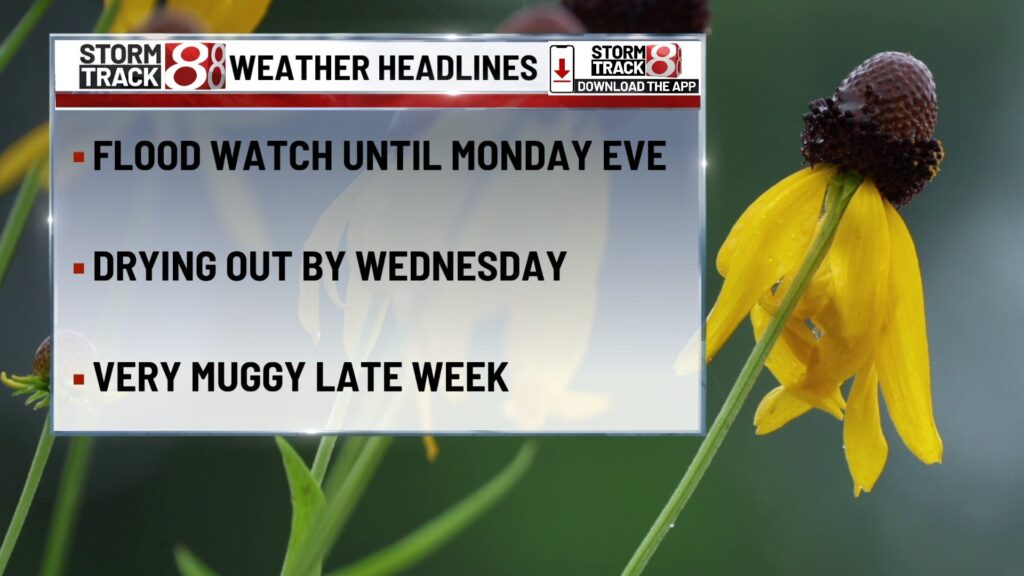
Rain returns late week:

The forecast should remain dry until at least early Thursday. A few pop-up storms may develop Thursday afternoon. Increased chances for rain and storms will begin Friday as the upper-level ridge starts to flatten, allowing for better precipitation chances. The best chance for rain appears to be at the start of the weekend on Saturday, with numerous showers and thunderstorms possible and highs in the upper 80s. Chances for storms will continue through Sunday to close out the weekend, with highs near 90°F. The long-range pattern keeps us hot early next week, with highs pushing 90°F through midweek, only returning to seasonable temperatures by the end of July.

The 8- to 14-day outlook also shows strong signals of above-average temperatures as we begin the month of August.

Demonstrators protest increased ICE funding

Demonstrators protest increased ICE funding

INDIANAPOLIS (WISH) — Demonstrators on Sunday gathered outside the offices of Indiana Republicans, protesting increased funding for U.S. Immigration and Customs Enforcement.

Dozens rallied outside Sen. Todd Young’s office in Carmel, calling for investments in communities, not ICE. The “Big Beautiful Bill” passed this week, which includes tens of billions in funding for ramping up deportations, adding 10,000 new ICE agents, and establishing detention centers for people in the country illegally.

“We’re here to say we want the government to invest in our communities, not in ICE, not in terrorizing our communities,” said Emily TeKolste, a protester. “That we deserve healthcare, we deserve housing, we deserve food, we deserve education, and that families deserve to live in peace.”

Simultaneous protests were organized outside offices for Representatives Rudy Yakym and Victoria Spartz. News 8 reached out for comment and has not heard back.

New look at IN-TF1’s rescue efforts in Kerr County, Texas

KERRVILLE, Texas (WISH) — Indiana Task Force 1 shared a new look at their deployment in flood-ravaged Texas. The team of first responders is now in their 12th day of helping with search operations along the Guadalupe River in Kerr County, Texas. The flooding that occurred between July 4 – July 10 has left the area muddy, wet, and debris-filled with rough terrain.

Task Force 1 is said to be in good health, focused on their mission, and asking to be kept in Hoosiers’ thoughts.

(Provided Photo/Indianapolis Fire Department via X)

Final Day of Indiana Black Expo 2025

Final Day of Indiana Black Expo 2025

INDIANAPOLIS (WISH) — Sunday was the last day for this year’s Indiana Black Expo.

The annual event has highlighted Indiana’s Black community since 1970. Everything from fashion, to art, and opportunity. Sunday’s finale saw wrestling matches, basketball, and the always popular Gospel Explosion.

“It means a lot to me,” said Andre Donaldson, a Gospel Explosion singer. “This is something I never, ever want to see go away. It’s very good for our culture, our city. It’s a big event with family gatherings. It just…it means a lot. A lot.”

Donaldson has been involved with the Indiana Black Expo for 45 years, and he encourages everyone in the community to get involved with the event next year, too.

WNBA All-Star Game and Indiana Black Expo bring 70,000 people to Indy

WNBA All-Star Game, Indiana Black Expo bring estimated 70,000 people to Indy

INDIANAPOLIS (WISH) — City leaders estimate that WNBA All-Star Game and the Indiana Black Expo drew more than 70,000 people to the Circle City this weekend for a nearly $10 million economic impact.

Saturday’s WNBA All-Star Game was sold out, with nearly 17,000 people packing Gainbridge Fieldhouse. Additionally, the Indiana Black Expo expects about 88,000 people to attend their 20-day event.

Events like this are what’s making the city a hotspot for hosting and the rest of the world is noticing.

If you search the word “Indianapolis” on LinkedIn, you’ll find countless posts from companies hiring, brands moving to the Circle City, and young professionals launching their lives in the city.

But, there’s something new the search populating. It’s the inaugural list of “cities on the rise” and Indianapolis is on it.

It’s an accolade that’s flattering to city leaders, but not surprising.

“This has become pretty normal for Indy, and it’s been pretty amazing to see things, just about every other weekend starting at the beginning of the year,” Indy Chamber Vice President of Marketing and Communications Joe Pellman said.

This weekend, it’s the all-star game in tandem with the expo, highlighting the growth. Pellman said there’s no other city that could pull both off simultaneously and seamlessly.

“This weekend is really the result of Indy’s two superpowers, which are speed and collaboration, but now with the WNBA All-Star game married with Indiana Black Expo, I mean, what an amazing opportunity to combine two major events in our downtown core, and also across pollinate those things across the arts across culture,” Pellman said.

To make the new LinkedIn list, you’ve got to offer more than just play. The company analyzed hiring data and home prices to sift through what spots around the U.S. are emerging the fastest.

Pellman says they’ve implemented key tools to make Indy a great fit for work and life.

“We built something called lifeinindy.com. That connects people to a group who we call Indy-fluencers, who are charged with meeting one-on-one with potential residents or those who have moved here and want a little deeper connection to the community,” Pellman said.

It’s not just people connecting with the Indy community, brands are clamoring to bring business here, and what was especially clear this weekend.

“We love that so many different brands have created new experiences in downtown, especially, Nike, Gatorade, Coach, a variety of really major brands that are not only showcasing Indy to the rest of the country, but showcasing it to the world,” Pellman said.

5 men arrested for child solicitation in Grant County

MARION, Ind. (WISH) — Deputies with the Grant County Sheriff’s Office and officers with the Marion Police Department on Sunday arrested five men for child solicitation.

Four of the men traveled from outside counties with the intent to engage in sexual activity with a person they believed to be a 13-year-old girl.

Law enforcement was contacted by Predator Catchers Inc., a civilian organization focused on exposing individuals attempting to exploit minors online. Once the suspects arrived at the meeting location, Predator Catchers Inc. notified law enforcement.

The following men were arrested and charged with child soliciation:

  • Isaiah Frye, 28, of Loogootee, Indiana.
  • Johnathon Sasser, 42, of Anderson, Indiana.
  • Joshua Stephen Keck, 39, of Frankton, Indiana.
  • Teddy Lunceford, 38, of Elkhart, Indiana.
  • Raul Escribano, 35, of Marion, Indiana (arrested by the Marion Police Department).

“Protecting our children is one of the most sacred responsibilities we have,” said Grant County Sheriff Del Garcia. “Thanks to the swift response of our deputies, the work of the Marion Police Department, and the alert from Predator Catchers Inc., these individuals were apprehended before any harm could be done. We will continue to pursue those who seek to prey on children and hold them accountable.”

Weather Blog | Tracking severe storms in southern Indiana

Watch live | Interactive radar | Storm Track 8 weather app | Watches & warnings Hourly forecast | Wind gusts

INDIANAPOLIS (WISH) — A batch of strong/severe storms will move across southern Indiana Sunday evening. Damaging wind gusts to 60 mph appear to be the main concern at this time. Torrential rainfall and dangerous lightning are also occurring.  

(WISH Photo)
(WISH Photo)

8:54 p.m.

Weather Alert: Severe Thunderstorm Warning for Greene, Lawrence, and Monroe County until 9:30pm.

Severe Thunderstorm Warning including Owensburg IN, Williams IN and Crane IN until 9:30 PM EDT

(Provided Photo/National Weather Service Indianapolis via X)

8:21 p.m.

Weather Alert: Severe Thunderstorm Warning for Greene County until 8:45pm.

Severe Thunderstorm Warning including Linton IN, Bloomfield IN and Lyons IN until 8:45 PM EDT. This storm will contain wind gusts to 70 MPH!

(Provided Photo/National Weather Service Indianapolis via X)

8:10 p.m.

Weather Alert: Severe Thunderstorm Warning for Greene County until 9:00pm.

Severe Thunderstorm Warning including Bicknell IN, Freelandville IN and Elnora IN until 9:00 PM EDT

(Provided Photo/National Weather Service Indianapolis via X)

7:46 p.m.

Weather Alert: Severe Thunderstorm Warning for Clay and Greene County until 8:30pm.

7:09 p.m.

Weather Alert: Severe Thunderstorm Watch for portions of the area until 1:00am.

7 p.m.

Weather Alert: Severe Thunderstorm Warning for Clay and Greene County until 7:45pm.

6:20 p.m.

Weather Alert: Severe Thunderstorm Warning for Clay County until 7:00pm.

9:55 a.m.

Weather Alert: Severe Thunderstorm Warning for Tippecanoe County until 10:30am.

Clark expected to miss Tuesday’s game in New York

INDIANAPOLIS (WISH) — Indiana Fever All-Star Caitlin Clark is expected to miss Tuesday’s game against the New York Liberty, according to head coach Stephanie White.

Clark injured her right groin during last Tuesday’s game in Boston against the Connecticut Sun. She was sidelined for Saturday’s All-Star Game and couldn’t participate in Friday’s three-point shooting contest because of the injury.

White said Sunday that she hadn’t seen Clark since Saturday night’s game in Gainbridge Fieldhouse but is confident she’s on the way to recovery.

“I think she’s progressing,” White said. “I think we’re continuing to address everything that needs to be addressed. She’s going to see some doctors and get some more tests run earlier in the week. I don’t expect her to be available on Tuesday, so we’re just going to continue to take it one day at a time and let her get her evaluations earlier this week. Once we’ve done that, hopefully we’ll have more of a clear mind of what it looks like.”

Clark said Saturday that she was making sure she enjoyed All-Star weekend before shifting all her focus to getting better.

“I mean, I’m not going to say I’ve been getting around-the-clock treatment,” Clark said before the All-Star Game. “I’ve been still trying to enjoy this weekend and having the balance of that at the same time and trying to soak all of this in, and once Sunday comes around, we’ll completely shift my focus to getting as healthy as possible.”

The Fever travel back to New York Tuesday and face the Liberty for the second time in a week. Tip-off is scheduled for 8 p.m. Eastern.

Caitlin Clark’s message on social media after ‘incredible’ All-Star Weekend

INDIANAPOLIS (WISH) — Caitlin Clark expected Indy’s first WNBA All-Star Weekend to be the best in league history. To her, it was exactly that.

Basketball fans of all ages poured into Indianapolis all weekend long, crowding sponsor activations and even selling out Saturday’s All-Star Game.

Even after a groin injury sidelined her from actually playing in the big events, Clark still took advantage of everything she could during the three days of festivities.

The two-time All-Star shared her excitement and gratefulness on social media Sunday, saying:

Incredible weekend in Indy!! Our organization gave everything to make this the best WNBA All-Star Weekend yet—and it delivered in every way. Grateful to call this city home and beyond thankful for the incredible fans who brought the energy and made it special

WNBA Commissioner Cathy Engelbert shared Clark’s sentiments, praising Indianapolis and the host committee for a successful All-Star weekend.

“(Indianapolis) clearly has been buzzing with basketball energy these past few seasons,” Engelbert said. “I wanted to extend a heartfelt ‘Thank you’ to Herb Simon and Steve and the Simon family, Mel (Raines) and Kelly (Krauskopf) and the entire Indiana Fever organization. Their passion and commitment has truly made this All-Star experience unforgettable.”

Clark now shifts her focus to healing her right groin injury and trying to get healthy as quickly as possible.

“I mean, I’m not going to say I’ve been getting around-the-clock treatment,” Clark said before the All-Star Game. “I’ve been still trying to enjoy this weekend and having the balance of that at the same time and trying to soak all of this in, and once Sunday comes around, we’ll completely shift my focus to getting as healthy as possible.”

The Indiana Fever are back on the court Tuesday as the go back to New York to face the Liberty for the second time in a week. Tip-off is scheduled for 8 p.m. Eastern.

More Indiana Fever Coverage

Storm threat lingers to start the week, then intense heat builds midweek | July 20, 2025

July 20 | Evening Forecast with Meteorologist Drew Narsutis

TONIGHT

Scattered showers and thunderstorms continue through the evening, and a few stronger cells could still pack damaging wind gusts or brief hail. Flash flooding remains a concern with rounds of heavy rain possible, especially across central and southern Indiana. A Flash Flood Watch remains in effect through 8 PM Monday. Expect a muggy night with mostly cloudy skies and lows in the low to mid 70s.

TOMORROW

Another round of storms is expected, especially during the afternoon and evening. A few storms may produce heavy rainfall or gusty winds, but severe weather looks isolated. Cloud cover and scattered rain will hold temperatures to the low 80s in many spots—though areas that stay drier could sneak close to 90. High humidity continues, keeping conditions uncomfortable even between storms.

TOMORROW NIGHT

Rain and storms gradually taper off during the late evening, but pockets of light rain may linger into the early morning. Flood-prone areas should be cautious, especially if they’ve already picked up heavy rain over the weekend. Lows settle near 70 under mostly cloudy skies.

TUESDAY

A refreshing break arrives Tuesday. Most of central Indiana stays dry under a mix of sun and clouds. With just a small chance for a pop-up shower southwest of Indianapolis, the day will be warm but not quite as muggy. Highs climb into the upper 80s with a touch more comfort in the air.

TUESDAY NIGHT

Quiet weather continues Tuesday night with mostly clear skies and lows around 70. Winds stay light out of the southeast.

WEDNESDAY

Heat and humidity return quickly. Mostly sunny skies and south winds will send highs into the low 90s, with heat index values nearing 100. A pop-up storm can’t be ruled out late, but most areas remain dry.

WEDNESDAY NIGHT

A warm and muggy night is ahead. Mostly clear skies with lows in the mid 70s. Little relief from the heat overnight.

THURSDAY

The heat peaks on Thursday. Highs soar to the mid 90s, and with oppressive humidity, heat index values will likely top 100 degrees. A few storms may fire during the evening, but coverage should stay isolated.

THURSDAY NIGHT

Partly cloudy, warm, and sticky. A slight chance of a shower lingers through early evening, with overnight lows again only dipping to the mid 70s.

7 DAY FORECAST

We’ll start the week unsettled, with more rounds of storms likely on Monday and a continued risk for localized flooding. By Tuesday, we catch a brief break—sunshine returns, and highs warm into the upper 80s with more tolerable humidity. But by midweek, heat and moisture surge back in. Wednesday and Thursday will be hot and very humid, with heat indices pushing or exceeding 100 degrees. Rain chances stay minimal until late Thursday. The heat holds into Friday, with a better chance for storms arriving late. Next weekend looks stormier, but slightly cooler, with highs dipping back into the 80s by Sunday.