
Marcus’ 4 a.m. Thursday forecast
INDIANAPOLIS (WISH) — A few gusty storms will be possible this afternoon for parts of the state.
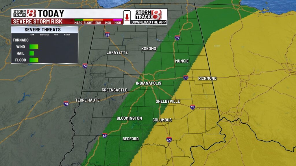
Thursday:
Unsettled weather continues for our Thursday. A warm front sliding to the north, with an attached area of low pressure and a cold front waiting to the west, will continue to agitate the atmosphere, providing numerous chances for scattered showers and thunderstorms throughout the day.

In the morning hours, expect scattered showers and possibly a rumble of thunder. The peak time for numerous showers and storms will likely be in the afternoon and early evening hours.

A few storms this afternoon could become strong to severe, with marginally severe wind gusts possible. The most likely area to see stronger storms will be in the eastern half of the state this afternoon.

It will also be breezy throughout the day, with gusts peaking up to 35 mph.

High temperatures will reach the low to mid-70s.


Thursday night:
Scattered showers and thunderstorms will linger into the evening hours but are expected to gradually taper off overnight.
Expect mostly cloudy skies with comfortable temperatures. Lows will fall to the upper 50s.

Friday:
Cloudy conditions will start Friday. The approach of a second surface low and frontal system will bring isolated to scattered showers by late morning. Shower and thunderstorm activity will likely increase in the afternoon, especially in the southern half of the state.
High temperatures will reach the upper 60s to lower 70s.
Wet & cooler weekend:
We’ve made changes to the weekend forecast, which now includes rain for both Saturday and Sunday. A cutoff low will bring scattered showers across our area on Saturday under mostly cloudy skies. The same situation is likely for Sunday, with cloudy conditions and scattered showers and thunderstorms, especially during the peak heating of the afternoon.


Due to the numerous rain chances, many areas could see around one to two inches of rainfall through the end of the weekend.
In addition to the cloud cover and rain, this cutoff low will bring significantly cooler temperatures, with highs only in the lower 60s for both Saturday and Sunday.

Extended forecast:
The upper-level low may linger into the first few days of the workweek. We’ll keep a chance for isolated showers, cloud cover, and cooler temperatures for Monday and possibly Tuesday as well. High pressure is expected to settle in by the middle of next week, allowing temperatures to rise back to the lower 70s with dry conditions.

Long-range patterns also show signs of warmer temperatures over the next 8 to 14 days.
About The Author
You may also like
-
IMPD: Weekend reckless-driving partnership arrests 4, tows 7 vehicles
-
IMPD arrests 4 downtown for illegal alcohol sales, seizes drugs and guns
-
Safety recall issued for 5.2 million pools linked to 9 drowning deaths
-
Top 8 things to do in Indy this weekend: Brickyard Weekend, Hot Wheels Monster Trucks live, Indy Lemon Drop Festival and more
-
Malcolm-Jamal Warner, actor who starred as Theo in ‘The Cosby Show,’ dead at 54