
Marcus’ 4 a.m. Monday forecast
INDIANAPOLIS (WISH) — Heavy downpours will present a flooding risk almost every day this week.
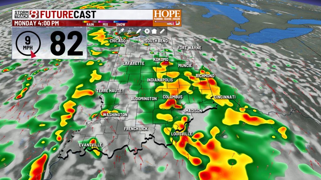
Today: Heavy Rain Arrives, Flooding Possible
An upper level disturbance lifting moving across the state today, combined with an exceptionally muggy atmosphere, will produce scattered to widespread showers and thunderstorms through the day, with coverage and intensity increasing this afternoon. Areas south and west of Indianapolis face the greatest risk of heavy, potentially flooding rainfall today.
The higher flooding risk is across northwestern counties and east-central areas — particularly from Lafayette southwest to the I-74 corridor west — where 2 to 4+ inches of rain has already fallen over the weekend. Those saturated soils have little capacity left, and even modest the lightest amount of rainfall could push streams and low-lying areas over the edge.

Rain continues into tonight before gradually diminishing as the trough pushes into Ohio overnight.
Tuesday: Morning Showers East, Clearing by Afternoon
a few light showers across the eastern portion of the area are possible through Tuesday morning. We should improve significantly by afternoon as the system clears to the east, Temperatures rebound into the upper 80s under clearing skies.
Wednesday: Afternoon Storm Chance
Wednesday brings more of the same sticky, summer-air — warm southwest flow, high humidity, and enough afternoon instability to pop isolated showers and storms through the evening hours.
Thursday and Friday: Strong Storms Possible
The extended forecast continues to highlight late Thursday into Friday as the most significant severe weather and flooding setup of the week.

Thursday will be hot and unstable. Dew points in the upper 60s to low 70s and strong afternoon heating push temperatures into the upper 80s to low 90s, loading the atmosphere with a lot of energy. Isolated to scattered pulse thunderstorms fire easily through in the afternoon hours.
Late Thursday, a cold front moves through Central Indiana — and that’s when the setup turns more rough with isolated storms forming into lines and clusters capable of damaging straight-line winds — the primary threat— and isolated large hail. With high moisture content in the air, any storms that train over the same areas will pose a serious flash flooding ris, particularly across the parts of Central Indiana that will have already absorbed multiple rounds of heavy rain this week.
Weekend: Some Relief
The cold front clears southern Indiana late Friday night into Saturday morning, and a strong Canadian high — will bring a sharp northwest wind shift, which in turn will bring cooler and drier air through Saturday. Highs will be a bit closer to average, but humidity will be dramatically lower.

About The Author
You may also like
-
Child killed in hit-and-run incident in Cumberland
-
Public asked to help find missing 6-year-old boy in Plainfield
-
Beau Bayh wins Democratic nomination for secretary of state in Indiana
-
Trump grants full pardon to ex-GOP Rep. Stephen Buyer in insider trading case
-
Man killed in hit-and-run crash in Fort Wayne, suspect under the influence, police say