
Marcus’ 4 a.m. Monday forecast
INDIANAPOLIS (WISH) — Central Indiana will remain locked into an unsettled weather pattern for most of the next week. We are going to keep at least a chance of some rain & storms in the forecast for parts of the Memorial Day weekend.
MONDAY EVENING/NIGHT:
Areas of rain & storms. Additional heavy rain could lead to flooding in some locations. A FLOOD WATCH is in effect until 11 PM for areas SW of Indy. Mild lows in the 60s can be expected.


TUESDAY:
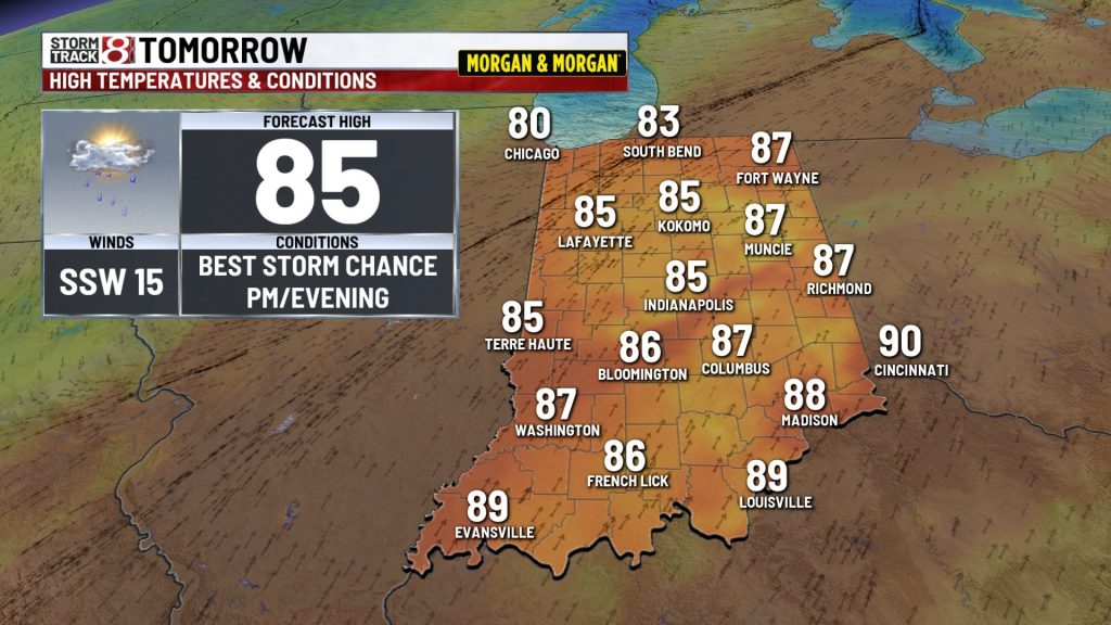
Another warm & humid day is on tap for Central Indiana. It may be a little breezy too. The chance of storms will be highest during the afternoon and evening. Once again, some of the storms could produce damaging wind gusts and torrential rainfall. Highs should be in the 80s before storms ramp up.


TUESDAY NIGHT:
Areas of rain & storms. Lows in the low 60s or upper 50s.
WEDNESDAY:
Chance of lingering morning rain. Drying in the afternoon. Partly to mostly cloudy and cooler with highs in the 60s to lower 70s.

THURSDAY:
Variably cloudy skies. Highs around 70.

FRIDAY:
Chance of rain & storms. Highs in the lower 70s. Fingers crossed for Carb Day at IMS but there could very well be some rain around at some point.

SATURDAY:
Clouds & sun. A chance for a few showers & storms. Let’s hope for the best for Legends Day at IMS and the big 500 Parade downtown. Highs in the mid to upper 70s.

SUNDAY:
Clouds & sun. A chance for a few showers & storms. We remain cautiously optimistic that we’ll be able to squeeze in the Indy 500 as scheduled but stay tuned for updates later in the week. Highs in the upper 70s to around 80.

MEMORIAL DAY:
Chance of a few showers and storms. Seasonably humid with highs around 80.

About The Author
You may also like
-
New e-bike rules in Fishers aim to curb dangerous riding
-
ECR provides update on Alexander Rossi following Indy 500 practice crash
-
Eastern Star Church buys former Martin University campus
-
Elderly woman dies after physical altercation at Fort Wayne Tim Hortons
-
New Indianapolis animal shelter reaches 110% capacity in just six days, needs community’s help