
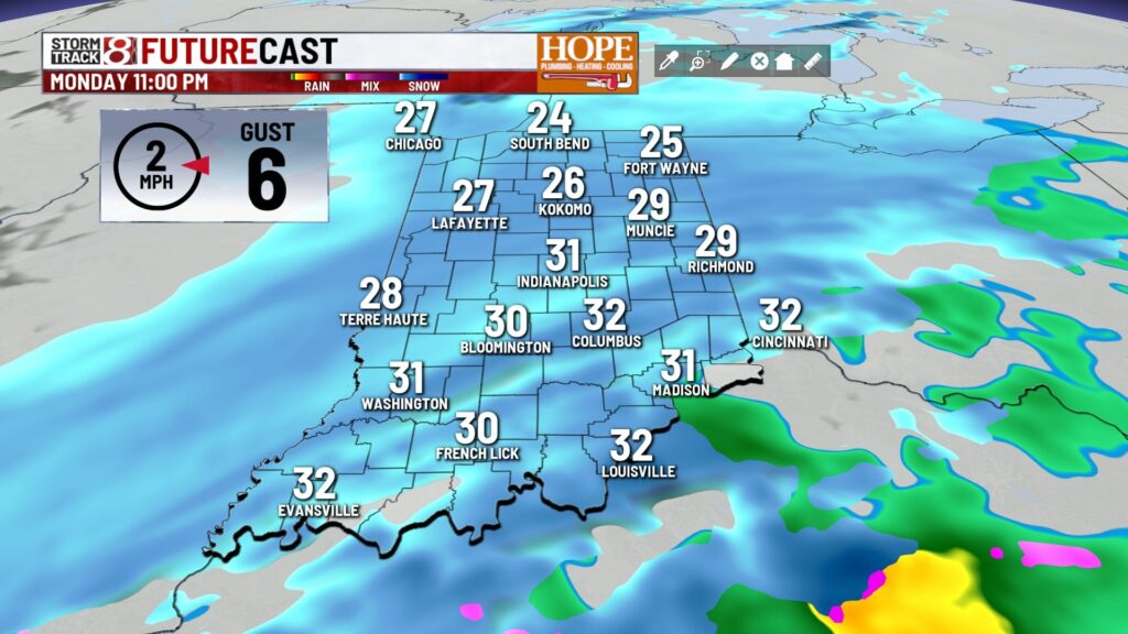
INDIANAPOLIS: A winter weather advisory has been issued for all of central Indiana. This alert will run from 7 PM ET today to 7 AM ET on Tuesday.

TODAY: Fog is present across north central Indiana this morning. Cloudy skies remain for today. Widespread light snow will be arriving this evening. High temperatures in the low to mid-30s.


TONIGHT: Steady light to moderate snow continues into the early morning hours. Snow will wrap up from west to east prior to daybreak. This will be an all-snow event, unlike the event this past weekend. Central Indiana can expect 1-3″ of snow. Low temperatures in the mid-20s.


TOMORROW: Even though snow exits prior to daybreak, it still may be a slick morning commute. Mostly cloudy skies remain. High temperatures in the upper 20s.


7-DAY FORECAST: Colder air than average continues all the way through the weekend. A few flurries may be possible on Wednesday/Wednesday night. Friday morning, we will be waking up to low temperatures in the low teens.

About The Author
You may also like
-
Multi-agency drug patrol in Indiana leads to 73 arrests, 150+ charges
-
Extreme heat warning issued as temperatures peak across central Indiana | June 30, 2026
-
Supreme Court upholds state laws banning transgender girls and women from school athletic teams
-
Braun says no decision yet on gas tax holiday extension
-
Beat the heat: Safety tips for Marion County residents during extreme temperatures