
Marcus’ 4 a.m. Monday forecast
INDIANAPOLIS (WISH) — Little relief is expected from the intense heat this week.
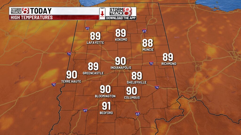
Today:
No significant changes in conditions are expected for Monday, with mostly sunny skies in the morning transitioning to partly cloudy skies by the afternoon. A few isolated showers and thunderstorms may occur in the northwestern parts of the state.

High temperatures will reach the upper 80s to lower 90s, with heat index values in the mid-90s.

Tuesday:
Tuesday will remain humid, with high temperatures in the upper 80s to lower 90s and heat index values in the mid-to-upper 90s.
An upper-level trough moving into the eastern part of the country will trigger scattered showers and thunderstorms from late Tuesday afternoon into Tuesday evening. While these won’t be widespread, they represent the best chance for rain in our area in several days. No severe weather is expected, but heavy downpours are possible due to the slow movement of developing storms.

Isolated storm chances will continue into Wednesday as the frontal system moves through, with the best chances likely along and south of Interstate 70. Temperatures will be slightly cooler due to cloud cover, topping out in the mid-80s.
7 day forecast:
Thursday will be dry and seasonal, with highs in the mid-80s. Another round of intense heat will build toward the end of the week and into the weekend, with high temperatures approaching 90°F starting on Friday and continuing through the weekend.

The long-term pattern shows strong signals of above-average temperatures over the next 8 to 14 days.

About The Author
You may also like
-
Deputies seek help finding 10-year-old boy with autism last seen walking into field
-
AI in Education: How Purdue University is guiding artificial intelligence use on campus
-
Farmers’ Almanac predicts ‘very cold, snowy’ Indiana winter
-
Most living at Fountain Square homeless camp don’t have housing ahead of Monday shut down
-
Bargersville Fire Department rolls out new tool to help EMS crews