
Marcus’ 4 a.m. Friday forecast
INDIANAPOLIS (WISH) — Dangerous heat in the region is expected to persist through early next week.
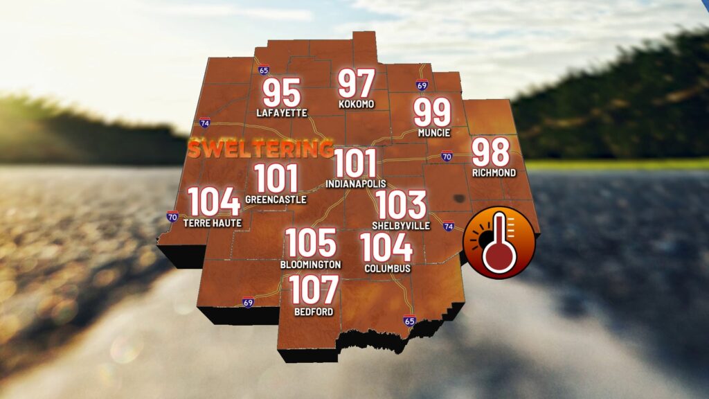
Today:
A weak frontal boundary stretches across the Midwest from Lake Erie, over northern Indiana, through Central Illinois, and into northern Missouri this morning. Some Clusters of showers and storms have been noted in the northern parts of the states, stretching back to the central Plains.
As this boundary sags southward, a few scattered showers and thunderstorms will be possible through the day, although there will be very limited opportunities heading into the afternoon hours.
The biggest story will be the intense heat again this afternoon. Heat advisories are in place for the central and southern portions of the state.

High temperatures will reach the low 90s, with heat indices around 100°F for the northern half of the state and could exceed potentially exceeding 105°F for the southern half of the state this afternoon.


Tonight:
Extremely muggy conditions with a few scattered showers and thunderstorms overhead are expected. Severe weather shouldn’t be a problem, but heavy downpours and frequent lightning will be likely heading into the overnight hours.
Weekend forecast:
Intense heat and high humidity will also be the theme for the weekend. It’s Highs are likely to reach the upper 80s to low 90s, with heat indices ranging between 95°F to 110°F both Saturday and Sunday.
Like Friday, scattered showers and thunderstorms will be possible, if not likely, on and off through the day on Saturday. There will be many dry areas and dry hours throughout the day, but do expect some heavy downpours to form, especially with the prime heating of the afternoon.
Sunday presents more widely scattered showers and storms as the heat doesn’t strengthen again. This should reduce the coverage of rainfall compared to Saturday.
7 day forecast:
The intense heat will continue at least through the first half of the new work and school week. Monday could match the hottest day of the season thus far, topping out in the mid-90s with heat indices pushing close to 110°F. Tuesday looks equally as hot, with highs in the low to mid-90s.
Both Monday and Tuesday will present pop-up thunderstorms with the heating of the afternoon hours. Widespread rain and storms are not expected.

As early as mid-week next week, we could start to see some relief diving in with Canadian high-pressure sliding through. Temperatures could be a good 10 to 15°F cooler than where we’re at they are now, and humidity should drop significantly as well.

About The Author
You may also like
-
HBCU Cookout in Indianapolis brings together alumni and students
-
Oak Ridge Boys to return to Wabash for Christmas tour
-
Heat and humidity linger with storms brewing by midweek | July 26th, 2025
-
Indianapolis brothers face high-level felony drug charges in Hamilton County
-
NASCAR Xfinity Series racing at IMS on WISH-TV