
INDIANAPOLIS (WISH) — Today felt fairly good out there with lower humidity and temperatures that were near normal for this time of the year. Unfortunately, all good things don’t last forever as we’re about to have an extended issue with high heat and humidity.
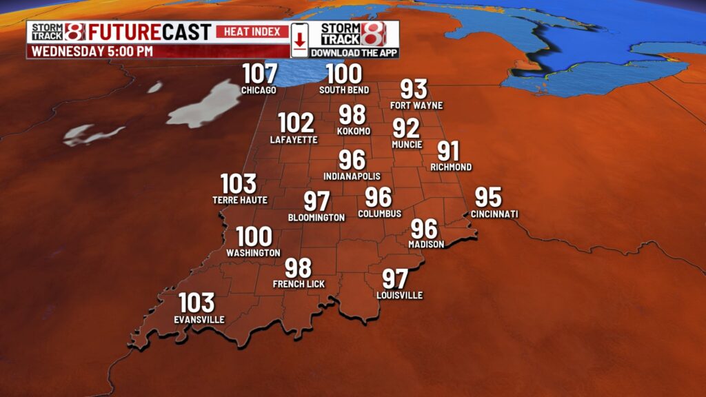
Heat advisories are currently in place across western Indiana for Wednesday afternoon and evening. These may get extended further east. There will also be an air quality alert for Wednesday.


Tuesday night: Mostly clear and decent for tonight with lows in the mid to upper 60s.

Wednesday: Tomorrow will be the first of a several day stretch of misery weather-wise. Highs in the low 90s, dew points rising into the low to mid 70s, and mid 90s to low 100s heat indices will make it feel terrible out there.


Thursday: The worst of this pattern of heat arrives Thursday with some locations tapping into the mid 90s for highs. Dew point values that look to push into the mid to upper 70s will cause heat indices to potentially approach 105-110 degrees. Now, there could be a caveat with Thursday’s forecast, especially for areas in northern Indiana. This would be increased cloud cover and a spotty shower/storm chance if it fully materializes.


7-Day Forecast: Sweltering conditions will continue into the final weekend of July with the hot dome beginning to break down a little bit by Friday. This in turn will increase rain and storm chances into the weekend. Exact timing and placement is still very uncertain with these storm chances.

About The Author
You may also like
-
Mother urges action after daughter grazed in downtown mass shooting
-
Woman killed, 2 seriously hurt in Fulton County crash
-
Here’s how some IPS parents envision the future of their schools
-
Chris Ballard on the Colts QB competition, playoff drought & more
-
Shane Steichen shares how Colts training camp will change this year