
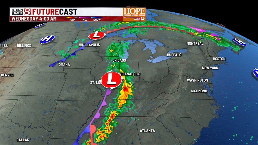
Marcus’ 4 a.m. Monday forecast
INDIANAPOLIS — We’re starting the workweek stuck under a blanket of low clouds with occasional patchy drizzle, but don’t let the gray skies fool you: temperatures are running well above normal and will peak on Tuesday before our next weather maker arrives.
Today
Expect overcast skies to dominate throughout the day with areas of patchy drizzle at times. We won’t see much temperature movement today thanks to the persistent cloud cover: morning temperatures will only dip to the low to mid-50s, and afternoon temperatures will struggle to reach the low to mid-60s. Not terrible for early November, but the lack of sunshine will make it feel raw at times.


Tonight
Look for some breaks in the cloud cover to develop late tonight, which will set the stage for our warming trend on Tuesday. Lows will settle into the low to mid-50s again, quite mild for this time of year.

Tuesday
This will be the pick day of the week. With improving sunshine and strong southerly winds pumping in warmer air ahead of our next system, highs will surge well back into the 70s. Winds will become breezy through the day with gusts of 35 to 40 mph possible by evening.


Wednesday
A cold front will push through late Tuesday night into Wednesday morning, bringing widespread showers and a few rumbles of thunder. The severe threat looks minimal due to limited atmospheric instability, but a few stronger storms could briefly mix down gusty winds to the surface, something we’ll be watching closely. The strongest winds will occur ahead of and just behind the front Tuesday night with gusts potentially reaching 40 mph or more. Showers will taper off late Wednesday as the front clears the area. Expect cooler temperatures to return with highs only reaching the low 60s.

7-Day Forecast
We’ll settle into a pattern near seasonal normals late week into the weekend with highs in the upper 50s to low 60s and lows in the mid-30s to mid-40s. A large upper-level low will hover over the Great Lakes region, which means we’ll need to keep slight rain chances in the forecast through the weekend. Additional disturbances rotating around this system could bring reinforcing shots of cooler air and more showers as we head into next week.

About The Author

You may also like
-
IMPD: Person stable after being shot on Monument Circle in downtown Indianapolis
-
9 dead after Bahamas-bound jet crashes in Florida, 600 people displaced due to damage
-
Colts fall to Jaguars in lopsided fashion as losing streak reaches four games
-
Overnight shooting in downtown Bloomington injures seven, police say
-
IMPD: Person shot on Indy’s south side near Madison Avenue