
Ryan’s 6 AM forecast 7/19
INDIANAPOLIS (WISH) — A big weekend in Indy with the WNBA All-Star game in town. Strong to severe storms are possible this afternoon and evening. Hopefully, we will have more breaks closer to the tip time of 8:30 PM.

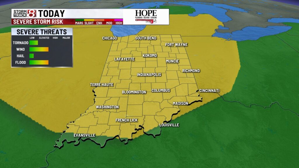
TODAY: Dry start with some areas of fog in eastern Indiana. A spotty shower or storm can’t be ruled out in the midday hours. However, strong to severe storms are on the table from 2 pm – 8 pm with damaging wind as the primary threat. A slight (2/5) risk of severe weather is in place for central Indiana. A quick spin-up tornado can’t be ruled out. High temperatures in the mid-80s.


TONIGHT: Lingering showers and storms are still possible. The severe threat will go down, but flooding remains a concern. Low temperatures in the mid-70s.

TOMORROW: Scattered showers and storms become likely for the afternoon and evening hours. A marginal (1/5) risk is in place for damaging wind. High temperatures in the mid-80s. Multiple inches of rain could fall in some spots south of I-70 this weekend.

7-DAY FORECAST: Heavy rain potential should be wrapping up Monday AM. Temperatures will be cranking up midweek with higher dew points making multiple days feel like 100+. Additional chances of rain enter the forecast late week.


About The Author
You may also like
-
Male dead after Fort Wayne shooting on River Run Trail
-
Tech company CEO resigns after controversy over video captured at Coldplay concert
-
WNBA All-Star festivities/Indy’s Home Court activations temporarily closed
-
Motorist strikes Lawrence Police Department vehicle; officer hospitalized
-
Second Helpings receives $10,000 grant to boost culinary training program