
Marcus’ 4 a.m. Thursday forecast
INDIANAPOLIS (WISH) — Several rounds of heavy rain, gusty winds are possible through the weekend.
Today:
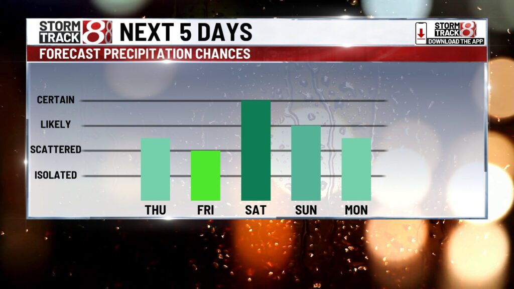
Thunderstorms are likely this afternoon, mainly along and south of I-70.

We have a level one out of five risk for severe storms in the southern third of the state. Isolated damaging wind gusts will be the primary concern, but any area, even outside the severe weather risk, could experience localized flooding. Rainfall amounts will range from a quarter to a half inch, though some isolated areas may see 1 to 2+ inches.
Meanwhile, temperatures will be seasonable, topping out in the 80s. With high humidity, similar to the last few days, the feels-like temperatures will range from the low to mid-90s.
Tonight:
Showers and storms will continue this evening but should gradually diminish overnight. The severe weather threat should be minimal, if not zero; however, minor flooding is possible with any storms that develop overnight.
Heavy rain this weekend?
Daily storm chances are expected to continue for Friday and into the weekend. The best rain opportunities on Friday will likely be in the southern portions of the state, though scattered storms around the metro area in the late afternoon and early evening hours cannot be ruled out.
Saturday and Sunday are more complex, as a front will fluctuate from north to south both days. Numerous waves of energy will move along this boundary, potentially triggering scattered showers and thunderstorms. Additionally, moisture from a tropical disturbance moving along the Gulf Coast late Thursday and heading north into the weekend may contribute.
It’s difficult to gauge the exact timing of rain, as confidence is low regarding the precise placement of the front this weekend. That said, the potential exists for excessive rainfall. The Weather Prediction Center has placed us under a slight risk for excessive rain this weekend, which could lead to localized flooding across the area.
High temperatures will remain seasonable, topping out in the mid-80s on Friday, Saturday, and Sunday. High humidity will create uncomfortable conditions throughout the weekend.
Hot next week:
Storm chances are expected to persist into early next week, but the main concern will be hazardous heat conditions arriving midweek. High temperatures are expected to reach the low to mid-90s. With extremely high humidity, heat indices will likely exceed 100 and potentially reach 105 or higher. Numerous heat alerts are likely to be issued for the middle of next week. As a large heat dome builds, storm chances will likely diminish by mid- to late next week.

The long-range pattern through the end of the month suggests temperatures will remain well above average for this time of year.

About The Author
You may also like
-
Caitlin Clark, other WNBA All-Stars make statement with shirts calling for higher pay
-
Hundreds of Indiana students receive free laptops during WNBA All-Star weekend
-
Team Collier bests Team Clark in WNBA All-Star Game
-
Greenwood woman killed in single-vehicle crash on I-65 northbound
-
Stormy weekend continues, dangerous heat builds midweek | July 19, 2025